Saturday, 29 April 2017

The Tortured Geology of the Mackay Coast

Many stony beaches near Mackay have an exceptional diversity of rocks. Even bedrock exposures reveal a complex series of rock types. How did the regional geology become such a complex mixture? 

Varied geology of Mackay Region
Diversity of rocks on shore of Taffy Island (Click to enlarge)
Firstly, the geology in other parts of Queensland is usually not like this. In Far North Queensland, the grand landscapes have large areas of uniform rock types such as basalt, granite and metamorphic rocks formed from hardened deep sea sediments. Stony beaches usually have rocks of similar geology.  There is nothing like the confusion of rocks seen on the Mackay Coast, where there can be several wild swings in geology within a space of a few metres. A single small island or bay may have more than half a dozen different rocks types and these rocks can be interbedded or mixed up in complex ways.

Breccia on beach at Cape Hillsborough
Breccia and basalt at Cape Hillsborough
Despite the crazy geology, the coastal landscape of the Mackay Coast has an almost painfully low topography and the geological wonders are pocket-sized rather than awe-inspiring tourism grade. The places shown in this post are mostly accessible by car and the remainder are close enough to reach in a small boat on a good day.  There are also a few islands that can be walked to on a low tide if you take care not be stranded by the huge tides near Mackay.

Vocanic ash features in Mackay region, near Whitsunday Islands
Red Cliff Island near Seaforth
The Mackay Coast and nearby Whitsunday Coast were shaped by the largest slicic igneous province on earth. Rather than issuing floods of basalt, the volcanoes of this igneous province were explosive and produced mainly volcanic ash. The Whitsunday Islands are mostly formed from water-laid deposits of volcanic ash which were compressed into stone. Time has filled the submerged calderas of the volcanoes that produced the Whitsundays with sediment and has hidden them from view. The positions of the calderas are inferred by changes in rock types on islands and the mainland.

Geology of Cape Hillborough, hardened volcanic ash island
A hollow island formed from fused volcanic ejecta
Recent scientific papers reveal the power of volcanic blasts from this province.  Some were so powerful, that sand-sized zircons were blasted up so high that they came down in Western Australia. In total, the volume of material discharged is estimated to have been approximately 1.4-2.5 million cubic kilometres. That would be enough material to cover all of present day Australia to a depth of more than 300 m. 

Geological feature in Central Queensland
Funnel Mountain (344 m, viewed from Taffy Island) is formed of volcanic deposits have been protected from erosion by a hard sandstone cap.
Just two years, it was discovered that the world’s longest continent chain of volcanoes starts at Cape Hillsborough (active ~32 million years ago) on the Mackay Coast. The Cosgrove volcanic chain as it is now known runs through inland Central Queensland, then disappears under a section of very thick crust, before re-emerging in Southern Victoria, approximately 2000 km away.  Volcanic chains are the result of a continent drifting across a plume of magma, known as a hot spot.

Geological tourist attraction
Metasediment cliffs on Outer Red Cliff Island
The volcanic episode that created the Whitsundays was associated with the separation of Australia from Antarctica and the relatively unknown other continent in our region, Zealandia. In addition to volcanism, the Mackay Coast has had intense cycles of rifting (stretching) and compression. Compression has tilted many of the originally low angled volcanic ash deposits to much steeper angles.  This tilting can be seen in the cliffs of Outer Red Cliff Island.   In other areas, solid masses of igneous rock have been cracked in every direction by the stresses.  I imagine that the process was similar to how ice is cracked by a moving glacier. Weathering along these irregular cracks may be the reason behind the jagged boulder beaches we see on the Mackay Coast today.

Rifting led to the creation of the granitic islands off the coast. Magma filled expanding rifts deep within the earth's crust and then cooled into granite. Subsequence cycles of compression resulted in faulting which uplifted and exposed the granite.  Where the surface sank due to faulting, basins were formed that accumulated sediment. New sedimentary rocks were formed including sandstone. Some of these rocks have also been uplifted.

Granite island near Mackay, Central Queensland
Foreground: Flat Top Island showing granite outcrop

Geological history of Central Queensland
Wedding Cake Rock (uplifted sandstone), Newry Islands
Unfortunately most of the Mackay Coast’s dramatic volcanic history has eroded away and only traces remain. Cape Hillsborough is part of the side of the only remaining coastal volcano. The crater has been lost to erosion and subsidence. The next nearest volcano is the Nebo Volcano which is 70 km west of the town of Sarina. There are however many volcanic features on the Mackay Coast that are associated with side vents and dykes. Most of the features of Mackay Coast and nearshore islands, including Taffy Island, seem to be a product of dykes.  Dykes occur where magma has forced its way into a crack in the overlying bedrock or compressed sediment. Heat from the cooling magma cooks the surrounding rock into a harder stone that can resist erosion and it is these rocks that comprise many of the nearshore islands.

Taffy Island
Taffy Island is located near Freshwater Point, Sarina. It is one of the few islands that I have been to rather that a specially selected example. At the eastern end of the 300 m long island is a dyke and the rocks in the contact zone have been cooked to produce much harder rocks. Moving away from the contact zone, the ground reverts softer rocks formed from volcanic ash. Volcanic ash breaks down to clay and much of the volcanic ash has turned into clay with the passage of time.  A single basalt rock, which might have been a basalt bomb lies on the beach in the middle of the island. As the nearest volcanoes are approximately 80 km away, the bomb possibly flew this distance to reach its current position.  Strong trade winds and high waves continue to shape the island today. Here is the geology of Taffy Island in photos.

Metamorphosed fine-grained hard rocks with a dull red surface protect the eastern end of the island.

Running through this area is a dull grey stripe of igneous rock, which is the dyke that many have metamorphosed the surrounding softer rock.

In areas that received less heat, the volcanic ash was only slightly hardened.

A brightly coloured rocky islet beside Taffy Island seems to be created from ash consolidated by heat. 

Basalt bomb
A single and quite large possible basalt bomb was present on the shoreline of the island.  Behind the basalt is the soft rock derived from ash that makes up most of the island. 

This is what a fresh basalt bomb looks like (Photo USGS)

The western end of the island has cliffs of unconsolidated clay and stone

Critically endangered littoral rainforest, Central Queensland.
Windswept grassland and horizontal metre-high rainforest attest to the strength of the winds
I am investigating the regional geology to understand the distribution of fauna and flora in the landscape, which is my profession.  This post has been prepared to provide an entry point to other resources which provide more detailed and peer reviewed information.  Background information used to prepare this post has been drawn from a number of sources including:


Saturday, 11 March 2017

River Monsters in Mackay?

Soft muddy banks are like a canvas that records the animals of the intertidal forest.  Incredibly delicate feeding patterns from fiddler crabs and fin prints from mudskippers can be perfectly preserved.  And so can the prints of much larger and more mysterious creatures.


There is no guide to animal tracks in the mangroves, and perhaps it is time to make one, but first I need to figure out what creatures are making the marks.


In the brackish headwaters of a small river near Mackay, I noticed that the tidal riverbanks were perforated with triangular pits that were the size of a man’s fist.  There were no footprints associated with the pits so this rules out birds and mud crabs.  The pits were too delicate for crocodiles.  That leaves only fish, rays and turtles.  The mud is not dug out; rather a face has been pushed into the mud judging by the raised lip of displaced mud around the pit.  A mouthful of mud seems to be gulped in.  Plugs of mud with mouth prints could be found scattered around beside the holes.  Some were ribbed, suggesting the creature’s mouth had a ribbed roof or that the mud was pushed out past grooves in the creature’s mouth.  Other plugs were curved and smooth.  The plugs of mud were as big as a cast from a human mouth would be.  


Each pit is about 10 cm long and are similar to coffee cup in volume

A 'mouth' print in the discarded plug of mud.

A smooth plug, which might represent the other lower surface of the plug.
Rarely some very unusual fin prints were found near the triangular pits. The tracks were about half a metre wide.  I suspect that these are from a different creature.

Mysterious track - sample 1 (click to enlarge)

Mysterious track - sample 2

The stream was too narrow to turn the boat and there was a good sized crocodile slide just metres away, so I did not retrieve samples.  The place was heavily pitted.  Fiddler crabs were the only obvious source of food on the riverbank.  They were present in extraordinary density and could barely be bothered to hide when I approached. 

Crocodile slide with polished belly patch and scratches from a largish croc.

The density of the pits in this are is similar to the density of fiddler crabs
Since then, I have started to see the triangular pits elsewhere.  On the tidal flats, there are also signs that fiddler crabs are on the menu.  Holes of a slightly different shape are present along with long cylindrical plugs of mud.

Round holes with fang grooves and long plugs of mud 

Whatever makes these strange marks is likely to be very hard to observe.  It is difficult to sneak up on animals in shallow waters, and the turbidity of the water makes using underwater cameras a challenge.  If you know which creature makes these tracks, please leave a comment.

Friday, 3 March 2017

Postcard from Clairview, Central Queensland

After traveling for hours through dry cattle country on Australia's national highway, suddenly encountering an uncanny light blue sea at Clairview makes a big impression. The township of Clairview is a string of houses along a beach without even a petrol station or a shop.  However, there is a caravan park where people can and should stop for a day and experience the late afternoon vista from the beer garden on the beach.

Beach at Clairview
Thirteen islands hover on the far horizon (click to enlarge)
The bright colour of the sea is from clay suspended in the water.  Huge tides slosh back and forth in the enormous and famously muddy Broad Sound which lies just to the south.  Mixing of these muddy waters with the clean blue Coral Sea creates the curious sea colour at Clairview.

Colour of the water at high tide in a mangrove creek
At low tide, sand flats stretch toward the horizon and hold the promise of interesting creatures to anyone brave enough to seek the low water mark. Large tides have a reputation for catching people unaware and sweeping them away. With that in mind, I thought I would take a look.

Stony shoals extent for hundreds of metres from tiny creek mouths
The seabed is like a wet desert. In places it has sand so fine that it flows around your feet like mud. Elsewhere, hard sand ripples form troughs that hold soupy liquid clay. Surprisingly most sandflat creatures like sand dollars and moon snails are not smothered by the sediment despite being immersed in it. Small sand crabs attack you in their crazy style of self-defense. Dugong feeding scars crisscross the sparse beds of seagrass. Sometimes there are turtle body prints in the mud.

Dugong feeding trails
Marine turtle body print
Portunus pelagicus
Baby Sand Crab on the defensive
The tide does not rush in so badly and anyone who can walk would be safe although it does gurgle as it flows over the rippled sand.

On the calmest of days the incoming tide stirs the sediments into milk
Near the beach is a sculptured layer of rock. All around the region, this concrete-like layer of rock also appears in the beds of streams both freshwater and marine. Vast areas of land in Central and Southern Queensland apparently have this rocky hardpan lurking just below the soil surface. It is an ignored geological feature as it is neither mineral or soil. The sole scientific paper I could find struggled to explain how and why the rock formed. It appears to be a relict from a past climate and is composed of aluminium and silicate compounds of similar chemistry to clay.  It is solid, contains embedded stones and is neither laterite or silcrete.

hardpan with encrusting oysters
Relict hardpan sculptured by the sea

Clairview Creek, Central Queensland
Hardpan studded with stones in the bed of the mangrove creek
The presence of this sheet of rock just below the surface makes the bush on the coastal plain struggle to survive as the shallow soils flip from very wet to very dry with the seasons. It is perhaps one of the reasons why Central Queensland has so little agriculture and so few people.  At Clairview the rock forms reefs that are encrusted with oysters. The hollowed and twisted stone shapes are strangely photogenic.

Definitely wear shoes, as every stone has a forest of oysters. The oysters grow vertically on the stone surface and colonies are like a shag pile carpet. Perhaps this orientation frustrates the oyster drills that feed on these colonies as moving over the colony that presents only sharp edges must be hard.

A small variety of oyster that stands on end.
Scattered along the coast and sometimes well out on the sand flats are small stands of mangroves. Some open stands of large trees resemble parkland.

Flock Pigeon Island lies just off-shore

Larger mangroves provide some handy shade
Clairview is a place of sand and sky and a milky sea. It offers a picturesque desolation and serenity.

See also: Wildlife of Clairview and St Lawrence

Wednesday, 11 January 2017

The Rakali, Australia's answer to an Otter

A Rakali is a large semi-aquatic rodent that is Australia’s closest equivalent to an otter.  They are also commonly known as water rats, however this name bothers me as the animal is clearly different from a rat.  Recently the Australian government decided that it was time to refer to native Australian animals using aboriginal names and Rakali is the name used for this animal by the people of the Murray-Darling river system.  Rakali are present across most of Australia, along both rivers and near the sea.
A Rakali (Photo: Mike Trennery, wettropics.gov.au)
The Rakali is a major predator of crabs, particularly the larger semi-terrestrial crabs such as the crabs that live in mangroves and ghost crabs from sandy beaches.   Seeing a Rakali is very difficult as they are nocturnal and usually, they are detected by footprints.  In mangrove swamps near Cairns, it is common for the mangrove forest floor to be almost covered with foot prints, such is the scale of their activity.  I suspect that their presence is one of the reasons why mangrove crabs are mainly diurnal.  In turn Rakali might fall prey to large owls and pythons which also visit mangrove swamps.

Front feet leave star-shaped prints and back feet, long prints with webbed toes
Rakali also forage along beaches and I often see their footprints in freshly reworked sand of creek mouths.  Recently I found Rakali track on the beach at Slade Point near Mackay and decided to follow them.  The beach is almost a surf beach and is exposed to strong winds and high wind waves.  At both ends of the beach there is a rocky headland and the Rakali tracks ran along the high tide line from one headland to the other.  As the tide peaked just after dark, the Rakali must have traversed the beach whilst there were still traces of sunlight in the sky.  It is an audacious move for such a small animal to travel a 850 m distance completely exposed.  On the way across the beach, the Rakali caught and ate a ghost crab.

Remains of the ghost crab
Rakali reach approximately 1.3 kg in weight with a body length of nearly 40 cm so they are much larger than rats.   They are known to forage almost 3 km a night, however I don’t know if anyone has previously recorded them crossing of 850 m km of exposed beach in a few minutes. 

Dangerous, rogue waves often wash 10 m higher up than normal waves
Photo of Lamberts Lookout in moonlight at 8:30 pm
Lamberts Beach, which the Rakali crossed
Rakali often drown in crab and yabbi pots, particularly in freshwater.  In South Australia, net crayfish pots have been banned due to the toll they take on turtles, Rakali and Platypus.  If you want to use yabbi traps, please check on the internet how to avoid wildlife kills. Rakali may not swim as often in estuarine systems as they would be prone to attack by large fish and crocodiles.  Tides also expose their prey, so they may not have need to dive.  

Tuesday, 6 December 2016

Giant Tides and Intertidal Fauna

Central Queensland has some highest tides in Australia, with a tidal range of as much as 7 m, and I was wondering what effect such a tidal range has on the intertidal fauna. 

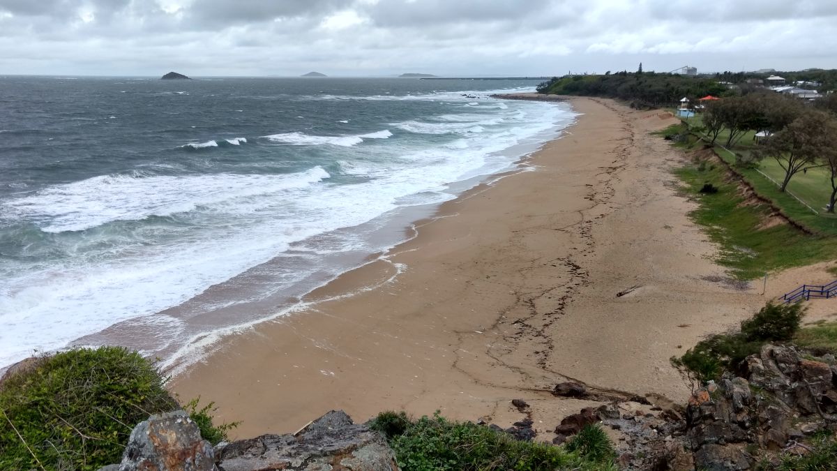
The rocky headlands on the Mackay Coast are spectacularly jagged with angular boulders seemingly arranged to present as many sharp angles as possible.  The way the boulders are stacked is reminiscent of the concrete the landing craft traps that were used in World War 2.  Could tsunamis or super cyclones have contributed to this artistry?  I do not know, all I know is that the boulders are shaped and arranged differently to what I have seen elsewhere.

The intertidal boulder field at Perpetua Point, Sarina is over 100 m wide. (click to zoom in)
So many of the rocks are sharply pointed
More than 100 km north at Ball Beach, fields of angular rocks surround the headland.
These complex and stable rocky landscapes should provide the perfect habitat for a wide range of intertidal fauna, but they are virtually barren.  In both the Cairns region and in the oyster growing areas of NSW, oysters are clustered in the mid to upper intertidal area but on the Mackay Coast, they are only to be found in the lower intertidal zone.  Barnacles present a similar story.  I would even suggest that this pattern extends to the small snails such as Nodilittorina which graze on the algal crust on the surface of boulders.  Usually, these small snails are present is such numbers that it is hard not to step on them, yet in Central Queensland, one almost has to search for them.  It will not be a small undertaking to figure out why this apparent intertidal paradise is all but empty. 

Oysters and barnacles cling to the low tide line, normally they are much higher.
It is not that oysters and barnacles are not trying to colonise.  Low growing mangrove trees have barnacles and occasional oysters growing on the twigs in their canopies.  Tropical periwinkles (Planaxis sultcatus) often had small oyster shells on their shells, something I have not seen before.  Even the gravel that forms shoals in the sand flats is almost carpeted with small mostly dead oysters.  On reflection, I think that salt is what makes the rocks so hostile.  Exactly how, I do not know, but the vegetation of the headlands is cropped by the wind until it is less than ankle deep.  I think the factor that cuts the vegetation on the hills is also the factor that makes the rocks so barren below high tide level. 

At least a quarter of the periwinkes at Slade Point had dead oysters on their shells
The low mangroves near the headlands are coated with barnacles (Slade Point)
Trees that are tall enough to walk under have barnacles in their canopy!
With 7 m tides, the sandy beaches are vast, being more than 150 m from the high tide mark to low tide level.   For comparison, Cairns has a 3.6 m tidal range and the beaches are about 30 m wide from vegetation line to the toe of the beach and Bribie Island near Brisbane which has a tidal range of about 2.2 m also has beaches of 30 m width.  The huge tidal range seems to fill the beach with water on a high tide and this water seeps out of the beach when the tide falls.  For a beach to be steep and narrow, swash running up the beach has to soak in, something that does not happen on beaches where water is seeping from the face of the beach, and the beach slopes in Central Queensland are very low.  A lower slope makes the beaches very wide.

You almost need wheels to get across the beach, Grasstree Beach near Sarina.
One of my interests are the filter feeders of the swash zone.  While I have only briefly looked at Central Queensland beaches, it seems that the filter feeders are almost absent.  A walk along the high tide line reveals very few wedge shells, which are the most common filter feeder in northern Australia.  My guess is that the rough choppy seas and huge tides combine to create an environment where the tidal migration that swash zone creatures need to undertake become impossible.  Filter feeding animals are present in the surf beaches of Southern Queensland, but surf is gentle on beaches in comparison to large chop.

Almost no bivalve shells are present in the tide line but pebbles are abundant (East Point)
At low tide, most of Grasstree Beach at Sarina is carpeted with the round balls made by sand bubbler crabs.  However, the upper part of the intertidal range seems to belong to insects not crabs.  The insects are almost invisible as they have excellent vision and tend to flee from people before we get close enough to see them.  Sometimes I see the shadow of flying insects more easily than the insect.  It is strange to share a place where our vision is excellent and visibility is great, yet there are creatures that can see you perfectly well but you can’t see them.  Shorebirds including seagulls somehow feed on these creatures which is frustrating when you cannot see anything.

Billions of tiny balls carpet the beach at low tide thanks to sand bubbler crabs
Sand bubbler crabs look like sand balls but seagulls still find them and eat them
On some beaches, tiger beetles run around at high speed to battle with other tiger beetles or prey on smaller creatures.  Tiger beetles flee from us and it is quite hard to get any closer than about 2 m.  I suspect the tiger beetles are preying on midges or sandflies.  On looking for these tiger beetles on the net, I discovered that the beach tiger beetle of the North American Atlantic coast looks very similar.  The North American tiger beetle in now an endangered species and there is an interesting story about how a once common species is now on the brink.  For me, it is vindication that the time I invest in understanding creatures that no one else notices is worth something.  
Tiger beetles mating on Grasstree Beach
The smooth wet zone belongs to the tiger beetles and the rest to the sand bubbler crabs
To see how different Central Queensland is from Far North Queensland, see links below:

Saturday, 12 November 2016

Baby Mole Crabs

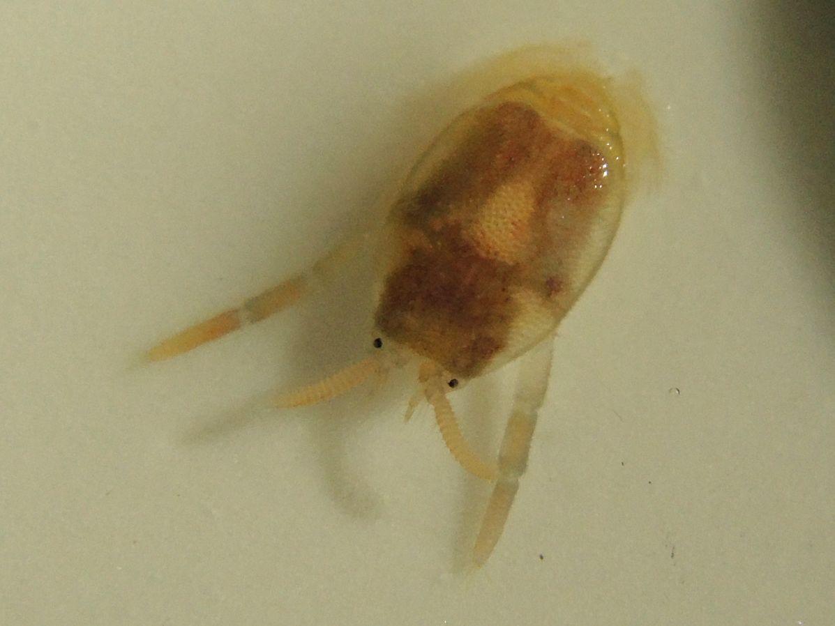
My observations sometimes form the main on-line documentation of some species and the mole crab (Albunea symmysta) is one of those.  Today, I was standing on Holloways Beach near Cairns, North Queensland, Australia when I started seeing little split pea-sized creatures zipping at speed across the wet sand after each wave.  They would dive into the sand a moment before it dried.   Within a fraction of a second after the swash had retreated leaving only wet sand between waves, they were moving 15-20 cm directly across the face of the beach (sideways, not up or down) and always to the north which was against the direction of the littoral drift.  I would see one every few waves and occasionally I would see a few moving at a time, perhaps 50 in 5 minutes.  It took ages to catch one to see what it was as I would only just see then dive into the sand before the next wave raced in and over them.
Juvenile mole crab ~5 mm long, probably Hippa pacifica (click image to enlarge)

Ventral surface of same crab showing spear shaped tail tucked between claw-like legs
Mole crabs filter feed with their antennae so are very strange crabs. Not much is known about them.

I was seeing the baby mole crabs near the peak of a king tide, both in the morning at about 7-8:30 am and again about 5:30 pm.  I have not looked at other times.  This is perhaps only the second time I have seen them in 30 years of scanning the beach for interesting things.  The weather was almost still in the morning and a 10 knot breeze produced a small chop that was crashing on the beach in the evening.  Only one factor was unusual, the beach had a small erosion scarp that was being attacked by the waves and creatures of the swash zone may have been trying not to be buried by the sand washing down from the scarp.

These observations help to fill in part of the life cycle of this most elusive animal and if anyone can add to these observations, feel free to comment.   I am not sure of the species but Albunea symmysta is the only mole crab I know to be present in the local environment and Hippa pacifica occurs on Lizard Island to the north.  Mole crabs are also in Indonesia and in India, however most of the information from these countries is on how to catch them or cook them.  The crab in the photos was released alive.  A video taken in California of a different species provides an idea of what juvenile mole crabs are like in the field.

Sunday, 30 October 2016

Pilot fish and Longtoms

Pilot fish famously follow sharks around, however it seems that this relationship is repeated on a smaller scale. I observed a longtom (also known as a needlefish) about 40 cm long hunting in the surface waters beside the Cairns waterfront boardwalk.  Then I saw that the longtom was not alone, it had a group of tiny fish following its every move.  Longtom are predators on other fish so following a longtom would seem to be risky for a little fish.   Additionally the longtom would zip a few metres forward to chase prey which I did not see and must have left the little fish behind.  Moments later, the little fish would be escorting the longtom again. 

Close-up of the fish escorting the longtom (click to enlarge)
The longtom appears to belong to the genus Tylosurus and I am not sure what the smaller fish are, possibly something in the tuna/trevally family.  Larger longtom occasionally spear people including sea kayakers as the sprint across the surface bouncing every six metres or so.  They tailwalk to pick up speed and will travel 20 m with only the tip of their tail in the water, the rest of their body in the air and leaning forwards at quite an angle.  Longtoms also apparently lack stomachs, something which I just found out. 
Longtom have a long beak filled with sharp teeth for catching little fish

The little fish would even swim on top of the longtom's head!