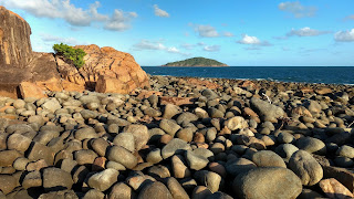
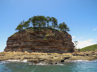
Many stony beaches near Mackay have an exceptional diversity of rocks. Even bedrock exposures reveal a complex series of rock types. How did the regional geology
become such a complex mixture?
 |
| Diversity of rocks on shore of Taffy Island (Click to enlarge) |
Firstly, the geology in other parts of Queensland is usually not like
this. In Far North Queensland, the grand landscapes
have large areas of uniform rock types such as basalt, granite and
metamorphic rocks formed from hardened deep sea sediments.
Stony beaches usually have rocks of similar geology. There is nothing like the confusion of rocks seen on the Mackay Coast, where there can be several wild swings in geology within a space of a few metres.
A single small island or bay may have more than half a dozen different rocks types and these rocks can be interbedded or mixed up in complex ways.
 |
| Breccia and basalt at Cape Hillsborough |
Despite the crazy
geology, the coastal landscape of the Mackay Coast has an almost painfully low topography and the geological wonders are
pocket-sized rather than awe-inspiring tourism grade. The places
shown in this post are mostly accessible by car and the remainder are
close enough to reach in a small boat on a good day. There are also a few islands that can be walked to on a low tide if you take care not be stranded by the huge tides near Mackay.
 |
| Red Cliff Island near Seaforth |
The Mackay Coast and
nearby Whitsunday Coast were shaped by the largest slicic igneous province on earth. Rather
than issuing floods of basalt, the volcanoes of this igneous province were explosive and
produced mainly volcanic ash. The Whitsunday Islands are mostly
formed from water-laid deposits of volcanic ash which were compressed
into stone. Time has filled the submerged calderas of the volcanoes that produced the Whitsundays with sediment and has hidden them from view. The positions of the calderas are inferred by changes in rock types on islands and the
mainland.
 |
| A hollow island formed from fused volcanic ejecta |
Recent scientific
papers reveal the power of volcanic blasts from this province. Some were so powerful, that sand-sized zircons were blasted up so high that they came down in Western Australia. In total, the volume of
material discharged is estimated to have been approximately 1.4-2.5
million cubic kilometres. That would be enough material to cover all
of present day Australia to a depth of more than 300 m.
 |
| Funnel Mountain (344 m, viewed from Taffy Island) is formed of volcanic deposits have been protected from erosion by a hard sandstone cap. |
Just two years, it
was discovered that the world’s longest continent chain of
volcanoes starts at Cape Hillsborough (active ~32 million years ago) on the Mackay Coast. The
Cosgrove volcanic chain as it is now known runs through inland
Central Queensland, then disappears under a section of very thick crust, before
re-emerging in Southern Victoria, approximately 2000 km away. Volcanic chains are the result of a continent drifting across a plume of magma, known as a hot spot.
 |
| Metasediment cliffs on Outer Red Cliff Island |
The volcanic episode that created the Whitsundays was associated with the separation of Australia from Antarctica and the relatively unknown other continent in our region, Zealandia. In addition to volcanism, the Mackay Coast has had intense cycles of rifting (stretching) and
compression. Compression has tilted many of the originally low angled volcanic ash deposits to much steeper angles. This tilting can be seen in the cliffs of Outer Red Cliff Island. In other areas, solid masses of igneous rock have been cracked in every direction by the
stresses. I imagine that the process was similar to how ice is cracked by a moving glacier.
Weathering along these irregular cracks may be the reason behind the
jagged boulder beaches we see on the Mackay Coast today.
Rifting led to the creation of the granitic islands off the coast. Magma filled expanding rifts deep within the earth's crust and then cooled into granite. Subsequence cycles of compression resulted in faulting which uplifted and exposed the granite. Where the surface sank due to faulting, basins were formed that accumulated sediment. New sedimentary rocks were formed including sandstone. Some of these rocks have also been uplifted.
 |
| Foreground: Flat Top Island showing granite outcrop |
 |
| Wedding Cake Rock (uplifted sandstone), Newry Islands |
Unfortunately most
of the Mackay Coast’s dramatic volcanic history has eroded away and
only traces remain. Cape Hillsborough is part of the side of the only remaining coastal volcano. The crater has been lost to erosion and subsidence. The next nearest volcano is the Nebo
Volcano which is 70 km west of the town of Sarina. There are however many volcanic
features on the Mackay Coast that are associated with side vents and
dykes. Most of the features of Mackay Coast and nearshore
islands, including Taffy Island, seem to be a product of dykes. Dykes occur where magma has forced its way into a crack in the overlying bedrock or compressed sediment. Heat from the cooling magma cooks the surrounding rock into a harder stone that can resist erosion and it is these rocks that comprise many of the nearshore islands.
 |
| Taffy Island |
Taffy Island is
located near Freshwater Point, Sarina. It is one of the few islands
that I have been to rather that a specially selected example. At the
eastern end of the 300 m long island is a dyke and the rocks in the
contact zone have been cooked to produce much harder rocks. Moving
away from the contact zone, the ground reverts softer
rocks formed from volcanic ash. Volcanic ash breaks down to clay and much of the volcanic ash has turned into clay with the passage of time. A single basalt rock, which might have been a basalt bomb lies on the
beach in the middle of the island. As the nearest volcanoes are
approximately 80 km away, the bomb possibly flew this distance to
reach its current position. Strong trade winds and high waves continue to shape the island today. Here is the geology of Taffy Island in photos.
 |
| This is what a fresh basalt bomb looks like (Photo USGS) |
 |
| The western end of the island has cliffs of unconsolidated clay and stone |
 |
| Windswept grassland and horizontal metre-high rainforest attest to the strength of the winds |
I am investigating the regional geology to understand the distribution of fauna and flora in the landscape, which is my profession. This post has been prepared to provide an entry point to other resources which provide more detailed and peer reviewed information. Background information used to prepare this post has been drawn from a number of sources including:


Appreciated.
ReplyDelete