Showing posts with label coastal processes. Show all posts

Wednesday, 25 May 2016

River Surfing in Cairns?

Just after writing about how the mouth of Barr Creek can have violent episodes, I was able to actually able to film another creek having one.  Deep Creek at Clifton Beach is about one quarter the size of Barr Creek and longshore often blocks its mouth with sand during the dry season.  Last week the mouth of the creek was a mere trickle and then we had a little bit of rain.


The creek came up so fast that a little old lady who went for a walk along the beach could not get back.  I had helped her wade back across by walking out into the sea and crossing where the force of the water was less.

Some people arrived and were quite worried that their big dogs would jump in and get washed away but dogs have skinny legs and seem to be able to walk through really fast water so they relaxed.  Then everyone just started having fun.  A man was trying to body surf the waves but his dog kept climbing on his back and riding him like a surf board which was really annoying.  .

This time I could stand in right beside the channel and film the biggest of the waves just in front of me and I saw a lot of things that I had never seen before and you can see some of them in the video.  The standing waves move slowly upstream.  When they get really big, they collapse into rolling surge of slosh and which is washed downstream leaving the surface of fast flowing water almost flat.  After a few seconds, a new set of standing waves formed and over twenty seconds grew to full size and then as before collapsed.  I always thought that ocean swells moved through the flood and made the standing waves peak but this is not the case.  The standing waves were in this case a self-generating cycle.  In some of the standing waves, vortices are making patterns in the crests of the waves.

In my search for information about standing waves I discovered that if Barr Creek was in America, people would go nuts about it.  The Waimea River on the Hawaiian Island of Oahu is their version of Barr Creek


Does Barr Creek really compare to the Waimea River?  They are almost perfectly matched - look at this.

Barr Creek with 500 m scale bar (images Google Earth)
Waimea River in Oahu, Hawaii
The difference is that Barr Creek has a maximum drop to the sea of about 3.5 m whereas the Waimea River drops down by 6-7 m as the beach is built up high by 10 m waves (their king tides are only 0.5 m!).  Barr Creeks standing waves top out at about a 1.5 m high whereas the Waimea River standing waves seem to be twice as big at full power.  Like the Waimea River, one has to wait until the mouth is blocked and the creek fills up with freshwater and when it is on the point of bursting out.  Kids sometimes dig a channel on a very low tide and off it goes.  Unfortunately this is not a common event.  However Barr Creek has several tide powered events every year and where the water drops about a metre between the creek and the sea and there is still plenty of action.  These  events are bigger than my video of Deep Creek.  The best time to play is when the creek is running fresh during the wet season and you do not have to worry about box jelly fish but you always have to look for crocodiles.


Saturday, 21 May 2016

How the Creek Ate the Beach

Strange combinations of normal events can synergise to do as much damage to the coast as cyclones.  As climate change kicks in and slight increases in sea level and slight intensifications of trade wind systems occur, these synergies become more significant as these events are likely to cause somewhat more damage and take somewhat longer for nature to repair.  In fact in recent years, most of the damage to the Queensland coastline in places that were not directly hit by cyclones, seems to be due to synergistic events.

A nice wide beach is just what you want on coming into the cyclone season
About 8 weeks later the beach was entirely gone leaving nearby houses highly exposed (23 Dec 2011)
Coming into the cyclone season, I was happy that the southern end of Holloways Beach had a 25 m wide crest that would provide an effective buffer against most cyclones.  A few weeks later this buffer had been entirely eaten away completely and trees were being undermined and some were falling into the sea.  The culprit was a combination of high tides and strong winds which is a regular and not very destructive occurrence, synergising with the meandering of the small tidal creek to create the most efficient beach erosion system I have ever seen. 

The eroding sand cliff was over 2 m high in most places 
In about 60 days, the mouth of Barr Creek moved by approximately 300 m and many thousands of tonnes of sand was removed from the beach.  In previous post I have covered how Barr Creek which is tiny tidal creek can become a serious geomorphological force when high tides combine with longshore drift.  In this post, I will describe how this same system became locked into a highly destructive cycle that resulted in the creek mouth rapidly migrating northward along the beach and eating away the protective foredune in the process.

Same position, looking in the opposite direction with the creek mouth in its normal state
Where Barr Creek crosses the beach, it meanders just like any other creek that flows through sandy ground.  Straight sections of creek begin to curve and curves grow more pronounced until they cut through the crest of the beach and new mouth forms.  Usually the meandering curves are restricted to the protected estuary side of the beach with the creek straightening just in time to pour into the sea.  Low swells and high chop often surge into the creek mouth on the incoming tide and dissipate their energy in the shallow waters over the sandbanks within the estuary.  As the sides of wave exposed creek mouth have a profile similar to the beach, the waves do little other than swash a few handfuls of sand from the beach into the creek channel and add a little more velocity to the inflowing tide.  This is the normal condition of Barr Creek. 

Sometimes the beach near the mouth is stable for long enough for beach vegetation and even trees to grow
Once every ten to fifteen years the creek has meandered to its maximum curvature and has created a high sand cliff that faces the ocean but which is protected from wave attack as the channel lies behind the beach crest.  High waves near the peak of a king tide can now wash right over the thin remaining beach crest that lies between the channel and the sea.  This delivers enormous amount of sand into creek channel resulting in continual narrowing of the channel at the same time as a king tide is trying to flood into the estuary. 
Washed over beach crest and narrowed channel, March 2015
The narrowed channel results in very fast currents that sweep away sand from the base of the bank on the landward side of the channel, creating a sand cliff.  The cliff retreats as unsupported sand falls into the channel and is also removed by the current.  At the same time, the washed over beach crest on the other side is being lowered and allowing waves to surge over the top, where they cross the creek and slam directly into the sand cliff.  Each time part of the cliff collapses; it is swept away by the extraordinarily strong currents in the channel.  The powerful wave and current attack on the sand cliff which faces the ocean is what eats the beach. 

Beach has just reached a critical state where waves can attack the outer bend (8 Aug 2011)
Creek is now locked into a northward migration (25 Sept 2011) - GoogleEarth Images
View of creek mouth on 24 Sept 2011 with kids playing in the current
Sand cliff or scarps also form on regular beaches during cyclones but they are usually much smaller being on 0.5 to 1 m high rather than the 2.5 m high sand cliff created where the channel has cut through the beach crest.  Also sand washed from the beach into the sea usually forms a protective offshore submerged sandbar that helps to reduce the level of wave attack on the beach.  In the case of Barr Creek sand eroded from the sand cliff helps to maintain the extreme currents that transport so much sand and this helps lock in the destructive cycle. 

Post Cyclone Larry (Cat 4) erosion scarp - the landfall was 100 km further south
Cyclone Larry seas were rough but not exceptional and the beach could easily endure
So far we have covered why the beach retreats so rapidly but we have not covered why the mouth of the creek moves along the beach at a high rate.  The whole process is driven by tidal currents moving sand.  Without the currents, the sand would just be swashed up and down the beach as it normally is and the beach would remain much the same.  When the mouth is migrating, longshore drift keeps delivering sand to the creek mouth forcing the creek mouth ever further to the north.  Outgoing tides passing through the narrowed, north pointing channel also deliver large amounts of sand to the creek mouth.  The result is long tapering sand spit that rapidly extends on the seaward side of the channel that constraint the channel to the base of the sand cliff.  In the next incoming tide vast amount of sand are swept over the sand spit into the channel forcing the channel back against the sand cliff repeating the process that eats the beach.  So the key element to the migration of the creek mouth is the rapid extension of the sand spit which is washed over at high tide.  The surprising thing is that the process is self-generating and can repeat for at least 30 days. 

When Barr Creek started to destroy mature beach trees, the council cut through the sand spit (23 Dec 2011)
The new mouth seen 6 months latter, however a 250 m long erosion scarp is still visible to the north
This geomorphological process converted a relatively safe beach into a highly exposed beach that could have enabled a cyclone to eat the whole beach reserve and threaten houses.  Events before my time may have been even more spectacular.  Long term residents say that the mouth of the creek was once a few hundred metres north of where it is now.  In a 1952 aerial photo, there is a hint of this being the case as the creek mouth seen in the photo has pushed more than 250 m north of its normal position.  Behind the current foredune is a freshwater lagoon which may have been created by the creek as locals say that the creek flowed behind the houses for a period. 

1952 Aerial photo showing the creek mouth eating the beach to the north
Behind the beach is a swale with a freshwater swamp full of Bullrush, the smooth patch in the above photo.
Another reason for understanding the behaviour of creek mouths is that they are often dredged to maintain channels for navigation or to provide sand for beach replenishment.  Currently the Moon River just north of Yorkeys Knob is being dredged and is causing terrible beach erosion in Half Moon Bay and now Richters Creek is being dredged to provide sand for replenishing Holloways Beach.  Each time the creek mouth is dredged, there is a massive impact on coastal processes in the vicinity of the creek mouth and I wonder if it these impacts are actually adding to the erosion of Holloways Beach in the long term.  These systems are complex and take years to respond to changed conditions so it would be easy to misinterpret action and response.

Most creek mouths are pretty stable and have been in the same position for as long as we have records.  Creeks like Barr Creek that have wandering mouths are comparatively rare.  Currently I know of only Barr Creek and Hartleys Creek at Wangetti Beach which are unstable and have mouths that regularly move by more than 100 m.  Larger creek mouths such as Richters Creek are also subject to similar processes.   As the watercourse becomes larger, the balance between the forces of tides and waves changes and it is probable that river mouths rarely migrate the way that smaller watercourses can.

Postscript

It took a few years for the beach to fully recover.  Whilst the face of the beach quickly recovers, there was a half metre deep hollow at rear of the beach as neither tides or wind penetrated to the rear of the beach to bring in sand.  Eventually, a combination of very high tides and rough weather resulted in waves that could swash right over the beach and into hollow.  As the swash drained back to Barr Creek along the hollow the water surged across the beach in one direction only and this quickly brought in enough sand to fill the hollow.  We have also recently had good sand supply from the Barron River and the beach has now grown tall enough to support large areas of beach creepers, something which I have not seen on the beach before.

Holloways Beach South in March 2016


Sunday, 3 April 2016

The Secret Power of Ordinary Coastal Processes

For a long time geomorphologists (people who study how landscapes evolve) thought that is was mainly day to day coastal processes that shaped our coastline.  Then came a realisation that many coastal features were in fact created by major events from super cyclones to tsunamis.  Major events then became the main focus of study.  But there seems to be another agent of change that possibly has as much effect as major events and this is synergies of ordinary events.  In more than twenty years of observations of the Cairns Northern Beaches, these synergies have caused more beach erosion than several major cyclones. In this post and a future post, I will describe two synergies that can move vast amounts of sand in periods of hours.


One of most dynamic sections of coastline near Cairns is Barr Creek, which lies between Machans Beach and Holloways Beach.  This tiny little creek is only 1.2 km long, yet it can turn ordinary tides into dramatic events.  Barr Creek is unlike all of the other creeks in the region as it is an ancient abandoned mouth of the Barron River.  The other creeks have catchments on side the mountain ranges and their channels are maintained by flooding rains draining back to the sea.  Barr Creek barely has any catchment at all, just fringing mangrove swamps.  In theory, when turbid seawater fills into the Barr Creek at high tide, sediment should settle out of the still water and rapidly fill the creek in.  This is exactly what happened in the nearby Blind Barron, a mouth that was abandoned approximately 70 years ago.  Yet Barr Creek maintains itself.

The mouth of Barr Creek migrates from side to side
Most of Barr Creek can be seen from the beach
Barr Creek 1 km upstream is almost too small to turn a small boat
Barr Creek's secret is that it has flood-like outgoing tides.  No other creek in the region has these.  I suspect that on highest astronomical tides (~3.3 m), seawater expands over an almost flat ground surface in areas with mangroves and salt pan.  As tides get higher, the area that is flooded increases exponentially and the volume of water in the Barr Creek estuary would be much greater for an extreme high tide than a normal high tide.  When the tide turns, all of that extra water has to squeeze out of a creek mouth that is always being narrowed as longshore drift fills the mouth with sand at a rapid rate.  Longshore drift occurs when trade wind driven waves strike the beach at an angle and their swash pushes sand along the beach.  On the outgoing tide, waters flood out through the narrowed mouth at high speed creating standing waves that can be more than a metre high.  Ocean swells also force their way up into the outgoing flood and momentarily transform standing waves into raging peaks of water as they pass.  When conditions were like this we used to drop everything and go white water rafting (the video does not show a full power day).  After the flood has surged more than one hundred metres out to sea it plunges through a rolling wave than marks the end of the flood and the start of the sea.

Underneath the surface the outgoing flood is a turbulent maelstrom.  The sandy bottom is not smooth but a complex pattern of mega ripples and swirling vortexes that vacuum sand of the bottom and inject it into the flowing water.  A single tide can transport enough sand to create an alluvial fan that extends 100 m into the sea and which would require more than 2500 tonnes of sand by rough calculation.  A continually rolling wave is located at the seaward edge of the alluvial fan.  Inshore waters are shallow so the alluvial fan ends with a steep drop of only half a metre.

Strong longshore drift removes the alluvial fan within a few days to weeks.  The same longshore drift brings new sand to the creek mouth where it is sucked up the creek to form an alluvial fan that faces upstream.  Sand accumulated in the creek mouth in this way provides material for forming a fan in the sea when the tide runs out.

Aerial view showing both alluvial fans.  The fan in the sea is 85 m long and is mainly from one tide.
It is amazing how big the alluvial fans can get.  At the front-left are a few mega-ripples
Beaches often seem to be static places, adjusting only slowly to the balance between accretion and erosion, however the truth is that every wave moves more sand than a good man can shovel in a minute.  Usually the amount of sand added and removed is in balance.  It is only in special places where sand movements are not balanced that true level of movement is revealed.

Kids love the high banks where the creek cuts into the beach
Getting rolled along by the incoming tide is fun too!
There is a funny side to the Barr Creek tidal movements.  Years ago Holloways Beach had a pub and Machans did not.  So people would come across the creek at low tide then go home in the dark.  At night you can’t see power of the water or its depth.  Many people have been swept away attempting to cross the creek.  Lucky they could all swim.  The incoming tide is pretty nasty too and some people got swept up the creek into the mangroves and you can imagine the fun: drunk in the dark and staggering through the mangroves.

On a particularly violent day when outgoing tide was reinforced with a freshwater flood, I was out there having fun when a rescue helicopter came out and started circling around me.  I was trying to surf the standing waves on a competition surf ski which can be paddled to about 15 km/h.  But the water was much faster and I would paddle upstream like mad whilst getting sucked backward through the flood until I caught a standing wave and hopefully surfed.  Of course you can’t see what is coming when you are going backwards which makes it very exciting and it is almost impossible to go through the roller backwards without coming off.  Beyond the roller is flat calm sea so you just get back onto the surf ski, paddle to the beach and go again.  Of course the rescue helicopter shows up just at the point of wipe out and thinks I am in trouble and started preparing to rescue me, which was embarrassing.

Barr Creek mouth widened to 60 m after a cyclone when Barron River water flowed through fields into Barr Creek 
In this post I have talked about how a synergy of ordinary events can create very powerful forces.  In a future post, I will show the damage this process can do when it combines with other ordinary events to create an extra-ordinary synergy.

For more information on coastal processes, see the subject index

Tuesday, 15 March 2016

Largest Landslide in Australia

The Captain Cook Highway, which runs from Cairns to Port Douglas is an iconic coastal road, yet it has a violent geological past that has too soon been forgotten.  Torrents of stone and mud have periodically transformed the landscape with the most recent event permanently burying parts of the original highway.  In some places where the current highway veers away from the beach, it is actually crossing over debris fields deposited in part by an immense recent landslide.  The primary historical record for this event appears to be a small Cairns Post article from Monday 15 January 1951 which reported:
“It will cost the Main Roads Commission many thousands of
pounds to repair a six-mile stretch of the Cook Highway between
Buchan and Simpson's Points, following huge landslides caused
by a torrential downpour lasting nearly five hours.
Almost unbelievable quantities of earth and debris were swept
from the mountain-side down on to the roadway and over the
precipice into the sea. Gigantic trees were uprooted and ground to
pulp, and boulders as high as 10 feet hurled into the Pacific- as if
they were marbles.
Millions of gallons of water cascaded down the mountains into
the sea, gouging huge ravines and making swiftly running streams
in the thousands of tons of earth and rubble left on the road in the
wake of the slides.”
Why are there no detailed records of the most violent landslide in Australian recorded history? Despite being in living memory and cutting the highway to Port Douglas for a few weeks, finding a photograph of this event or even a map of where it occurred seems to be impossible.  I have been trying to piece together what happened for a few years now and the story just gets bigger.

Near Cairns there are a number of places which are prone to these massive events, which could be up to 1000 times larger than the tragic Thredbo landslide.  These events could cause serious loss of life and property and there needs to be less complacence about this issue.

Approximately 2 km north of Ellis Beach are a few pretty sandy beaches with boulder headlands at each end.  A further 1.5 km north there is a boulder beach that is 3.5 km long.  The origin of the boulders on this mostly ignored stretch of coast is the subject of this post.  The native bedrock of this coastline is a slate-like metamorphic stone whereas the boulders are granite so it is clear that the boulders came from somewhere else.  These boulders provide a means of tracing the debris flows back to their origins.

Coastline with round granite boulders
A boulder beach near Ellis Beach in Far North Queensland (Click to enlarge)
For a moment lets stay at the boulder beach.  Relative to surrounding coastlines, it is a biological desert.  There are no oysters, barnacles, macro-algae and very few limpets and grazing gastropods.  I saw some trails in the sand from nerita snails, which is odd as they normally live on rocks. Perhaps the grazing snails which should be present in countless millions are being knocked off the smooth stones by waves.  Even under the rocks, there is hardly any life.  The round shape of the rocks means that even a large stone provides almost no shelter below.  I do not think that the rocks roll around in normal rough weather, this coast is a sheltered coast and the stones are very large being from 50-80 cm.  The slope of the beach is also very low and would gradually dissipate wave energy.  In contrast, at a nearby steeply sloping, south-east facing beach with 20 cm cobbles, it is possible to hear and feel vibration from rocks being tumbled around in the 1.5 m beach break.  On the boulder beach, I think that polishing by sand and lack of shelter from the elements makes this environment so hostile to marine life.  Large boulders that stand further out to sea have the expected level of life.  On the boulder beach, the only notable lifeforms were the strange black rings of blue-green bacteria, which are a stone-like encrustation.  The rocky shore of Island Point which was covered in a recent post makes an interesting comparison.
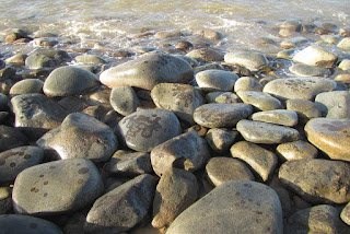
Almost lifeless boulder beach
Sand polished boulders near low tide level
In Google Earth, you can see that there are many small creeks flowing down the coastal escarpment and each appears to have delivered stone to the coast.  Between the creeks are hard metamorphic hills which constrain the positions of the creeks and hence direct the flow of stone.  All of the boulder headlands have formed in the mouths of creeks.  Between the creeks are very steep hill faces that press against the beach.  These slopes may look like an obvious source of stone but inspection reveals that these metamorphic hills make very little contribution.

Aerial view of Simpsons Point
Landslide debris creates headlands on Captain Cook Highway
Simpsons Point from the side, showing boulders pushed into the sea by a debris flow
In the aerial photo near the highway are patches of dark green forest.  These forests grow on debris fans that have spread out and settled before hitting the sea.  Pockets of dry rainforest find protection from fire in rock-rich debris fans.  Close to the top of the aerial image, is a potential source of stone as the bedrock switches to granite part way up the 700 m tall coastal escarpment.  Small areas of bare rock slab can be seen.  Granite begins 250-350 m above sea level and approximately 750 m from the sea when measured horizontally.  That is a long way for thousands of tonnes of stone to move.  Some of the largest boulders that can be seen from the highway are nearly 8 m in diameter.  Evidence for how the stone moved so far is best found by following the small creeks up toward their origins.

While most debris fans have dry rainforest, the debris fan in the catchment explored in this post had a glade of cycads that was more than 100 metres across.  Cycads are at their best in rocky ground.

Cycad understorey in eucalypt woodsland
The glade of cycads
Climbing up toward the top of the debris fan, the rock content of the soil became more obvious.  Between the rocks are seasonal herbs such as hibiscus (H. meraukensis) and Polynesian arrowroot (Tacca leontopetaloides).  At the edge of the debris fan, the vegetation of the glade suddenly gives way to the vegetation of metamorphic hills; ironbark and kangaroo grass woodland.

Herbs that spring up from bulbs during the wet seasons fill spaces between the cycads
Ironbark woodland
Ironbark woodlands cover metamorphic hills beside the old debris flows
Beneath the woodland vegetation is a thin skeletal soil over solid metamorphic stone.  On some of the steeper slopes, the rock is so close to the surface that grass cannot grow, though trees can exploit cracks between the vertically tilted layers to obtain what they need.  With time and weathering metamorphic reluctantly breaks down into flakes of rock and then clay without producing boulders.  Only when competent metamorphic bedrock is exposed by rivers and streams does this rock form boulders.  Initially the boulders are blocky but with time the edges are worn away.  Yet the boulders nearly always retain flat surfaces in contrast to granite which forms round stones.

A naturally bare patch showing metamorphic rock fracturing and flaking
Solid metamorphic rock lies below the surface
Above the debris fans, the creeks follow deep gullies incised into metamorphic bedrock.  Debris flows are not as nimble as water and rather than flowing down the watercourse, they tend to fill it up like a glacier.  A creek which was 5 m wide may be filled with a stream of stone and earth over 50 m wide.  At the centre of the debris flow, the deposited material may be 4-6 m deep.  Stream waters have to find a new way down the gully and usually form new channels on either side of the debris flow.  Between these channels, the consolidated debris flow becomes a raised strip of bolder strewn forest which develops its own distinct vegetation.  When stream waters erode the edges of the debris flow, they create vertical faces that allow the depth and make-up of the debris flows to be examined.

Cardwell lilies
Cardwell lilies fill the understorey on the new forest in the gully
Unaltered material from the stalled debris flow
Red earth and stone between the tree roots show the original character of the debris flow
Fresh landslide debris would contain as much earth as stone, but over time the earth washes away, leaving only the stones.  Trees which have grown on the landslide debris end up with roots looping trough the air as the ground settles and washes away.  Interestingly the remnant debris flow contains a red earth that appears to be of metamorphic origin, and not decomposed granite or sandy clay which is associated with granite boulders that form in situ.  This mix of geologies suggests a mechanism for these massive landslides.

A contact zone slip plane with a layer of weathered metamorphic rock resting on top
The mountains beside the Cook Highway formed when magma rose up into cracks that formed in the deep deposit of ocean sediments at a time when the east coast was under tension.  The sediments were cooked into metamorphic rocks and the magma solidified to form granite.  All granite forms at least two kilometres below the surface and is then uplifted, however usually the stone into which the granite intruded has long eroded away leaving only the granite geology.  Along most of the Cook Highway, the granite is still in the process of losing its cover of metamorphic rock.  Between the metamorphic rock and the granite is a contact zone which is a hard, almost mirror smooth surface probably composed of melted marine sediment.  These surfaces are steeply sloping and are hundreds of metres long.  There is no more perfect slip plane.  At the top of the mountain is exposed granite, which weathers in the usual fashion and creates boulders.  They mystery is how hundreds of thousands of tonnes of earth and boulders suddenly become mobile and I don't really know so I am going to speculate about what I think happens.  The slope is approximately one in three, which from my carefully conducted experiments of rolling rocks down slopes, is the steepest slope where rolling rocks are more likely to come to rest than keep rolling.  Usually they come to rest after after hitting an obstacle or a few inefficient end over end tumbles.  Many boulders created by weathering of granite outcrop might roll down until the collide with trees or terrain and collect on the mid-slopes of the range which have metamorphic soils.  Soil and small stones washed down from the kilometre long slopes above the exposed rock faces may also build up over time on the rock faces, creating landslide fuel for the future.
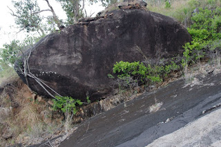
Giant boulder resting on steep slope
A big rock that almost kept rolling
red earth on a steep slip plane
A wedge of soil on a slip plane. The slope in the foreground probably shed its load.
In deducing the mechanism for these landslides, It would really help to know where the landslide originated, above the mid-slope granite exposures or below?  Unfortunately, it does not appear that this information was recorded for the 1951 debris flow.  Geosciences Australia  (GA) in their report titled Quantitative Landslide Risk Assessment of Cairns (AGSO RECORD 1999/36) estimates that the landslides described in this post brought down between 180 000 and 720 000 tonnes of material and buried sections of highway to a depth of 3 m.  GA consider that the rainfall event that triggered this landslide has a return interval of about 400 years, however that does not factor in climate change.  The key issue may also be accumulation of material over a slip plane rather than rainfall and the rate of this process was not  estimated in the report.  I would think that the return interval for large landslides could be in the order of 100-200 years.

When the ground does let go, the one thing that is certain is that the debris flow hurtles down the gullies.  Beside the small creek I followed, the debris flow averaged 30 m wide and formed an elevated inclined plain.  It is likely that nearly all the trees present in the gully would have been ripped from the ground and carried away.   Occasionally, when a few large trees formed a row across the gully, they were able stand against the debris flow.  These trees by virtue of their being there to halt part of the debris flow provide indirect evidence that the flow occurred decades ago, not hundreds of years ago.  In many places the sides of the gully were scoured back to bedrock.  The evidence shown here is repeated in most of the creeks on this section of coastline.  On some of the larger and most damaged creeks, the vegetation has not recovered.  When the trees were destroyed, tall exotic grasses and lantana moved in to form a blanket of weeds that have suppressed the regeneration of forest.
The sloping surface of the old debris flow occupies the middle of the gully
A few trees stood against the onslaught and built a wall of rocks
Burdekin plum tree (Pleiogynum timoriense) on debris field.
The tree on the right has roots at two levels showing that it has seen 2 debris flows.

Saturday, 25 April 2015

Cairns' Disappearing Mudflats

The famous Cairns mudflats are almost no more. This muddiest of places and magnet for migrating wading birds is becoming a sand flat. Some people think that the Council’s efforts to make a sandy beach is responsible for the gradual loss of this internationally important shorebird feeding area.  Certainly the amount of sand being placed on the esplanade should be investigated, however other factors might be at play including cyclones and coastal processes. 

Cairns' fine man made beach
Cairns is one of a very few places where you can sit on a boardwalk and view a dozen or more species of usually shy wild birds feeding only metres away. The birds can’t afford to be shy as there are few good feeding grounds in either direction. I once commissioned professional ornithologists to study one of the major estuaries to the north of Cairns. Port Musgrave on Cape York Peninsula should be ideal wader habitat. However we found that when the waders are migrating, it was always high tide during the day so the waders could not feed there. It takes a special set of circumstances to create good wader habitat. 

A wading bird less than 10 m from my seat and feeding in the small remaining muddy area near the birdwatchers lookouts.
The rich wader habitat in Cairns may also be partly of human creation. The shape of the coastline has been changed due to developments like the Pier and this has created a poorly flushed area which is great for accumulating mud deposits. Long before the Pier arrived, Fogarty Park which juts out into the estuary had been reclaimed. In the Cairns hinterland, land clearing was at its peak and there was much less concern for soil erosion at the time. Sediment supply from the Barron River, Trinity Inlet and even Saltwater Creek near the airport would have been much greater. Saltwater Creek now only drains urban areas, but when I was young this area was cane fields and would have yielded more sediment. The local Port Authority also pulls out all the mangroves which are attempting to colonise the mudflats just off the esplanade. This creates an open muddy habitat in an area that would normally be a dense mangrove swamp. Harbour dredging in times past would have had less consideration for sediment plumes and many think that these are the source of the Cairns mudflats.  Historically, Cairns is said to have had a sandy beach. However in my imagination, the sandy beach would have risen above a mudflat as in Cardwell today. This was the case in aerial photos from 1952.

Another wader feeding on the lumpy mud-scape near the wading pool - where the mud builds up today
I have been trying to establish a time series photographic record to make the changes over time visible. Unfortunately, nobody expects a fact of life such as the Cairns mudflats to disappear, so there is not much in the way of old data. However it is obvious that at least in some places, the mudflats are becoming sandy as you can now walk out a long way without sinking up to your knees. The question is where is the sand coming from and/or where is the mud going.  Similar changes are also occurring at Ellie Point which extends from northern end of the Esplanade. If massive changes have been taking place even quite far away from the sandy beach where the council dumps sand, it suggests other factors are involved. 

Dredge working in the shipping channel - note lack of life on exposed tidal flats which occupy the bottom half of the photo .
An almost matching view from 2005.
Telephoto view of the flats - the black object is a beer bottle (2014)
The same area in 2005 was seething with life 
The full story is complex and I am only undertaking informal investigations. It is probable that there is less mud coming out of the rivers. Even the sea on the Cairns Northern Beaches is more blue than brown these days. It used to be the colour of milk coffee in rough weather. Sand supply has also increased due to banning of sand mining in the Barron River and at Ellie Point. This supply which is estimated to be 23 000 tonnes a year is beginning to pour around the tip of Ellie Point. The renewed supply of river sand could already be making a minor contribution to the sand supply on the esplanade. Cyclones may have had a bigger impact. At Cardwell, Yasi washed away vast volumes of surface mud and left only the heavier sand. Several big cyclones have passed close to Cairns in recent years.  It is the swells that they generate that do the damage and these swells can change our coastline even when the cyclone is hundreds of kilometres away by creating inshore currents and by lifting sediment into the water column. Cyclones have always been around but there has been less time between large events recently.

In 2005, seagrass beds were clearly visible from the Esplanade (the dark band).  They appear to have disappeared from most of the Cairns foreshore.
The gradual loss of large areas of mudflat from Cairns probably has multiple causes and it would take a lot of work to apportion blame. If you are interested in helping to figure out what is happening leave a comment.  All the photos here were taken from near Muddies Playground.