Behind the mangroves of the great inlets of Western Cape York Peninsula are vast grasslands that can be a few kilometres wide and many kilometres long. This post shows a grassland at Port Musgrave and some images of Unigan nature reserve in Weipa.
 |
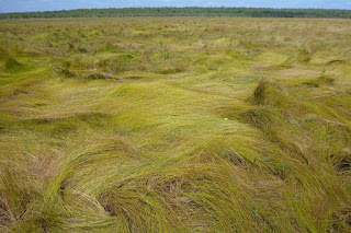
| Looking toward bauxite plateau over a sward of salt tolerant sedges (click to enlarge) |
These grasslands, which are also known as marine plains, form an extended transition between sea and land. Marine plains have an imperceptible slope, descending at 1 m per kilometre from landward edge to mangrove edge. Within the plain, the vegetation gradually changes from seasonal freshwater wetland to saline marine flats.
 |
| View of wet blady grass flats near bauxite plateau with mangroves in distance |
The grasslands are both spectacular and a challenge to the senses. Their great uniformity offers no secrets and it is tempting to leave after a few minutes. Yet this is a unique and productive ecosystem and if you can adjust your perception, there are things to be seen and environmental lessons to be learned. People used to live in these areas, how did they survive?
The dangers of these areas that needs to be considered before setting out to experience them. Savage
feral cattle which were set free in this area over a century ago and without much parasite resistance, are crankier than modern cattle. Feral pigs seek out the best patches of wetland and turn them into hectares of muddy slosh. After walking through these areas I needed treatment for hook worms, which created thin itchy trails of blood beneath my skin. The well-known threats of crocodiles and snakes are probably less of an issue here than elsewhere as they are not easily found even when searched for. In the dry season fire is a serious risk. When all of Cape York Peninsula is on fire, the air becomes thick with smoke and distant views are lost. Fire is often out there but you don’t know exactly far away it is, so it pays to have firm ideas of how to escape in the event. I have not seen a grassland burn, but I imagine it makes its own winds and would be a fierce unpredictable hazard. Most grasslands are burnt annually. Finally during the wet season, grass swamps can be heat traps where the air is still and humidity reaches 100%. In the worst conditions, human endurance is about ten minutes. Even dark still waters can become so hot that they are above the threshold of pain. Warning over, lets continue.
 |
| These things are more of a health hazard than crocs |
Surrounding the inlet is a thin band of mangroves. A single high tide every 24 hours (not two as is normal) would not provide enough flushing to keep dry season salinity down. The neap tide-spring tide cycle would leave many areas to dry out for weeks on end. It is very saline close to the inlet. The inner edge of the 100 m wide mangrove fringe has a strange thicket of club mangroves with swollen stems and salt encrusted leaves. In a few places tall succulent shrubs are present, which resemble cactus with fine branches.
 |
| Mangrove fringe around inlet showing zonation of species with increasing salinity. |
 |
| Inner edge of mangrove fringe has a thicket of club mangroves (Aegialitis annulata) |
 |
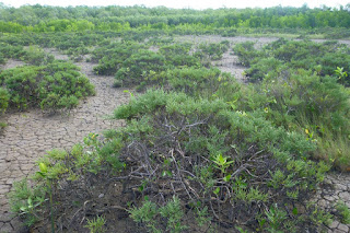
| Small areas have unusual shrublands with 1 m high succulents (Tecticornia indica) |
A narrow saltpan separates the mangroves from the grasslands. Soils in this area are swelling-cracking clays. These black clay soils which are normally found in inland areas swell greatly when wet and conversely shrink and crack deeply when dry. Few tree species can endure this type of ground movement. Well below the the low ridge that marks the limit for regular spring tides, there is a strange grassland which must flood with seawater many times each year.
 |
| Xerochloa grassland fringed with Batis. Mangroves in distance |
 |
| Large cracks let the soil dry out |
 |
| Xerochloa imberbis has tiny leaves and mainly uses stems for photosynthesis |
Landward of the king tide ridge lies a broad sedge flat. The heaving of the soil probably creates small round Gilgai wetlands in which Chinese water chestnuts (
Eleocharis dulcis) grow. Pigs seek dig up many of these wetlands and may have even created a simple agricultural system, where they deepen and improve the swamps that grow their food. Humans can eat the tubers as well and they taste great, raw or cooked.
 |
| A large spring-fed drainage line with Eleocharis reeds and stunted mangroves. |
Despite heavy rains, drainage lines in the grassland are tiny or non-existent across most of the grassland. Rain would have to drain across flat ground through decomposing vegetation and even dense beds of aquatic plants that spread below the grass. Before the water could drain, more rain would have fallen keeping the area wet for months on end. In the dry season, the flatness and impervious clay soil ensure that once the surface moisture is gone, drought will commence suddenly and be unrelenting. This is an ecosystem that switches between being waterlogged and drought stricken.
In bauxite areas, freshwater seeps out of springs and into the grasslands from the base of the jump-up that separates marine plain from bushland. Until the beginning of June, these areas have lush grasslands, with grass taller than a man. Then in August/October, these areas burn. The total loss of vegetation is hard for small wildlife to cope with and the area has many pigs and dingoes, both of which are major predators so there is very little wildlife even frogs. Poor nutrient status of the soils probably also contributes to the scarcity as even cattle do not thrive here.
 |
| Panicum trachyrachis wet grassland |
 |
| Floating Azolla fern, bladderworts and other species form an aquatic understorey |
 |
| Stems of grassland burned before completely dry (~August) |
In Unigan Nature Reserve, which is near Weipa, signs of the original aboriginal
people who lived grassland-mangrove boundary remain. They ate cockles in vast
quantities and discarded the shells form huge heaps which rise
above the grasslands like artificial islands. Native fruit
trees provide shade. How they fished for cockles in the
crocodile capital of Australia and how they survived nights with
mosquitos that drill into bone, I think those secrets are lost.
 |
| Cockles were on the menu |
 |
| One of the heritage-listed shell mounds that is in the middle of a grassland and close to the mangroves |


No comments:
Post a Comment