Thursday, 22 October 2015

The Uplifted Coral Reefs in North Queensland that were used to Discover Ancient Sea Levels

I have been told that when the graves in Port Douglas cemetery were dug there was a layer of hard coral under the sand.  The Port Douglas peninsula which is anchored at the end by Island Point was apparently once a coral reef.  Fortunately in some nearby places fossil coral reefs are exposed and the ancient corals can be seen.  The best place is Yule Point, which is 5 km south of Port Douglas.  
Most of the fossil coral reefs lie in shallow pools on the sand flats - click to enlarge
The fossil coral reef is probably 1-5 thousand years old as the sea was about a metre higher in coastal areas at that time.  It is not that sea level has fallen, rather the coastline has risen up a little.  The reason is iso-static rebound which is common phenomena in lands that were covered with ice sheets during the last ice age.  The weight of the ice sheets pressed the land down and when the ice melted, the ground slowly lifted up out of the sea and this process continues today in places such as Northern Europe.  Locally iso-static rebound works in the opposite direction with the submerged continental shelf being push down by the weight of the Coral Sea resulting in a slightly bending of the Australian Continent.  The downward thrust of the continental margins creates a small uplift at the edges of the exposed landmass.  This uplift raised many nearshore coral reefs up out of their tidal zone and created the fossil reefs that can be found today.
The irregular raised patches are fossil coral colonies
The fossil coral reefs are not that glamorous to look at but they are scientifically important.  The provide one of the best  lines of evidence for how high sea level once rose.  In particular scientists look for micro-atolls as these provide a very good record of sea level height.  Below is a micro-atoll growing in the rocks on the headland at nearby Oak Beach.  Normally they are completely round but the ones in this photo are compressed against stones.  See how precisely the cut-off level for coral growth is defined, this is what makes micro-atolls such good indicators of ancient sea levels.

A micro-atoll has a dead centre and a ring of living coral around the edge.
Oyster reefs and band of barnacles are also used but are less precise.  Barnacles usually grow in the over a wide vertical range on exposed rocks due to the splash zone so scientists seek out deep fissures in rocky coasts where waters are less likely to be splashed.   On Magnetic Island, a band of scattered barnacles occurs between the granite boulders that about 1 m above where barnacles are found today and this band has been carbon dated to approximately 4000 years before present.  Deep rocky fissures are rare on the coastline north of Cairns but do exist.

Barnacle covered cave wall near Port Douglas
On the wall of the fissure above which is about a metre wide and two metres tall are vast colonies of barnacles.  The living barnacles are purplish and dead barnacles are green with algae.  There is a distinct cut-off between the solid mass of barnacles in the lower part of the photo and the ribbed growth of barnacles at the top.  However if you look closely, there are a few scattered living barnacles on the green ribs which detracts from the ability to use barnacles for measuring sea level.

The following photos show some of the ancient coral colonies.  Erosion of the ancient coral surface is evident in most places and much of the original surface features have been replaced with textures created by erosion.

Rings show that this was a micro-atoll
This coral colony at nearby Little Reef Beach might be the same species.
Remains of a rosette coral 
A living colony off the beach at Little Reef Beach
One of the massive coral colonies even had the remains of  two burrowing clams in it
(centre of photo)
The round objects are the ends of stag horn coral and very hard and totally immobile
Being quite close to high tide level, there is little marine life on the uplifted corals, mainly hermit crabs and the occasional green sea cucumber.  Despite the apparently low levels of visible life, many species of migratory wading bird were busily feeding in this area.  On the sand flats away from the beach, each pool had its own ecology and had a different array of seaweeds and fauna.  The most interesting discovery were tiny starfish that occasionally encrusted blocks of ancient coral rubble.


Further Reading.

Sea levels of the Great Barrier Reef: assessing past changes using oyster bed deposits

This paper is short and easy and has a good graph of how corals, oysters and barnacles were used to understand ancient sea levels.

http://www.ainse.edu.au/__data/assets/pdf_file/0009/47286/r_09070P.pdf

Post-glacial sea-level changes around the Australian margin: a review

This paper provides the full story but is rather heavy.

https://research.jcu.edu.au/tropwater/resources/Lewis%20et%20al.%202013%20Post%20glacial%20sea%20level%20change.pdf

Friday, 28 August 2015

Seashell Coast - Pormpuraaw

One of the most remote towns in Australia is the Aboriginal Community of Pormpuraaw.  It is 210 km from the highway and approximately 500 km from the nearest town with more than 1000 people. The coast has a kind of desolate character that appeals to me.

Pormpuraaw foredune
Between the beach and the road is a grassland scattered with trees (Click photos to enlarge)
On arrival, I bought a pie and went down to be beach to eat it.  When I looked up, I found that I was being watched by no fewer than three medium to large crocodiles.  They were not sneaking up on me, rather I had just arrived where they sun on the beach near the river mouth.  Pormpuraaw has crocodiles up to five metres long and it is one place you do not want to take risks.

Estuarine crocodile
One of the crocodiles that was watching me
Pormpuraaw town is built on a couple of beach ridges made of sand and seashells and is wedged between an enormous salt pan and the sea.   Near the town is desert-like beach 8 km long and in many places the face of the beach is almost entirely seashells.  The shells are large and perfectly formed and it feels like a crime to walk on them.
Shells on Pormpuraaw Beach
The beach is at least half seashell, and the drifts are all shell
Close up of the seashell drift that runs across the middle of the photo above.
The sea is usually flat as Pormpuraaw is on the west coast of Cape York Peninsula and the prevailing trade winds blow offshore.  Pormpuraaw is in the Gulf of Carpentaria and this area has only one tide a day and has a reduced tidal range.  Actually, I am not totally sure, there are some places on the Australian coastline that do not have tide gauges and are hundreds of kilometres from a place that does.  The Gulf is also a bit strange.  Gove, which is one side of the Gulf has two almost equal tides each day and Port Musgrave, which is directly opposite has only a single tide each day.

Beach with a washed up sea fan in the foreground
Near Pormpuraaw, at low tide sand flats are exposed but they are flat and have neither the level of wildlife or the interesting patterns that I find elsewhere.   What is present are dead shells from two of the worlds largest molluscs, the bailer shell and the Australian Trumpet.  The shell of the largest Australian Trumpet ever found was about 91 cm long is actually the largest living shelled-gastropod.  However most of the trumpet shells at Pormpuraaw are about 20 cm long and few are in perfect condition.  Bailer shells were used for bailing boats, hence their name.  Broken shells of both species are common.

A small bailer shell
At either end of the Beach is a river and there are some huge crocodiles in these rivers.  I did not have a boat and took my photos just from the riverbank.  Mind you, I have a superzoom camera.  Would you believe that there were deep human footprints in the very soft mud along the waterline of the riverbank directly opposite where I photographed this crocodile!

Middle reaches of Chapman River, Pormpuraaw
Chapman River about 2 km from Pormpuraaw town
Sunbaking saltwater crocodile
5 metre crocodile on opposing river bank
If you go to Pormpuraaw, be sure to ring the Council first and make sure that their camping ground or guest house is open.   Allow about 3 days and be prepared to do something slow.  It has spectacular bird life, photogenic scenery and the locals are great.

Salt pan near road to Pormpuraaw

More about tides: I actually wanted to put in a tide gauge and be the first person to understand the local tide. Tides are the result of resonances between celestial bodies and the geometry of tidal basins and there are a large number of possible resonances.  I was surprised to find out that tides do not really flow in and out according the nice sinusoidal curve shown in tide charts.  There can be as many as six tides a day and an incoming or outgoing tide can reverse direction for a few minutes before resuming its original direction.  The observed tide is the result of several slow motion waves added together and these waves all move to different rules.  

To measure the tides, all that is needed is a self contained pressure gauge with integrated data logger.  Anchor it to the seabed in a sheltered location and collect at least two weeks of data.  Computer programs can then analyse the data and  make a tide chart.  I would probably like to collect more data as seiches may also occur in a place like the Gulf where the sea is shallow and strong winds blow.  This stuff actually matters.  In some harbours in Queensland, the amount of coal or ore that can be loaded into a ship is calculated according to what the tides are doing so as to maintain exactly 1 m clearance under the hull as the ship passes over the shallowest point. 

Saturday, 25 July 2015

Barron River Sunset

At the very same time that I was staring at sand for the tiniest insects that the human eye can see, there was another person on the sand flats photographing the scenery with the best camera I have probably ever seen. The camera was a 36 mega-pixel Nikon D800 full frame DSLR using prime (fixed length) lens. Prepare to see the Barron River sand flats as you have never seen them before. Click to view.

Machans Beach, Barron River Mouth


Machans Beach Sunset

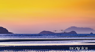
The photos show what we would see if we could look into the sun. I talked to Tony as he waited for the clouds to fire up.  There are a few minutes each day when the clouds are lit from below with the red sunlight of the setting sun.  Trying to be of value, rather an annoying person, I mentioned that the pelicans come in fast and low at about this time of day as they head to their night time retreat.  Tony took up the challenge.  It was about half an hour after the sun had set before the first pelicans showed up in silhouette against a sky orange with volcanic dust.

As the pelicans have to fly into the trade winds, they tend approach the river in the wind shadow of tall trees then suddenly drop down to a metre above the ground to fly under the wind.  Their flight path is almost predictable so we could let them come to us.  A disappointingly low number of pelicans had gone past and the sky was now so dark that even black and white pelicans were hard to seen.  But at that moment Tony spotted some pelicans flying further out and keen to show what a top end professional camera can to took some photos of the distant flock passing in the blue-black of early night.  The results are below and show something quite amazing, the flock of pelicans was being lead by a Black Swan!

Pelicans flying above sea


Pelicans being lead by a black swan


There are a lot more photos of our tropical coast on Tony's web site.
Photo I took of Tony when he was photographing the sunset.


Tuesday, 14 July 2015

Miniature Insects of Tidal Sand Flats

Sometimes if you just look hard enough you may see something no one else has seen.  Unable to find the time to go somewhere new, I decided to sit on the edge of a sandbar and watch at the seawater gradually draining from the sand and I kept up my concentration until I saw something that I had never seen before.  Tiny flecks of life appeared to be moving around on, under and above the water surface above black patches of mangrove debris.  Moving above the surface implies insects and insects the size of dust particles can fly through water as well as air! However it was hard to believe that such infinitesimally small creatures could survive in an environment that lasts only a few hours before the tide comes in violently reworks the very ground.  I can remember ten men trying to open a metre wide channel from a nearby blocked creek to the sea.  Such is the rate at which the sand is moved around that digging like mad they could not open the channel faster than the sea could fill it back in. Yet it is in this ocean of highly mobile sand that the flecks of life are present.
The sand flats can look like this one day (click to view)
I described these insects to the entomologists at the local university to a muted response.  It was uncomfortable to call what I had seen a community or ecology as how can a community exist when the very terrain is destroyed and recreated every few hours.  Worse still, finding the flecks of life a second time eluded me.  Even scraping up the mangrove debris and going through it under a microscope failed to yield anything other than a few larval crabs.  For nearly two years I have been looking. If I put a bright LED torch on the sand at night, flecks could be seen jumping through the beam.  However the nights are seldom still and it was difficult to be sure that the flecks were not flakes of matter propelled by the breeze.
Hours later the sand flats can be a very different place, in this case turned over by stingrays
A few days ago, I tried the old trick of just looking until I saw something, this time in a different place and I rediscovered this lost community.  Perhaps this community is only present in the winter (June-July) or perhaps it is only present in certain areas.  I am yet to work this out.  It was late in the day and the sun was so low that the shallows had become dark yet anything on the water surface was still illuminated and suddenly the true number of these little creatures was revealed. To see the creatures, you must approach the waters edge with great care as the weight of a foot fall even a half a metre away gently shifts the sand, causing the sand to slump just slightly and warning the little creatures to depart the area.  Video confirms that they are moving around the edges of the water, as I cannot easily see them with the naked eye.  I can only see them on the surface of the water and here they are caught by the wind and streak across the surface so quickly that in a few video frames they are gone.  Falling into the water does not seem to bother them and may in fact be part of their normal habitat.

A rill between sand ripples at the mouth of the Barron River
Springtails floating on the water seen in silhouette
I filled a small bottle with surface water and took it home for a look under the microscope.  Even under a microscope at 40 x the creatures are small.  They proved to be springtails, small wingless insects that can fly by flicking themselves into the air with a spring-like rod that folds under their body.  To the naked eye they look white or brown (could be a few species) but the brown ones are actually bright yellow.  The captive creatures were placed on a drop of water on a black surface and I photographed then with my compact camera held over the eye piece of the microscope.  The first photo shows the springtail beside a fine blonde human hair.  The other photos show the springtails rolling around on the surface of a drop of water.  Under the abdomen in the last photo is the spring that gives springtails there name.


Springtail beside a human hair


Are the springtails just a curiosity or are they important?  Their sheer numbers probably make them important and potentially they are food to the many juvenile fish that live in the pools.  Aside from that, I wonder if their yellow colour is a sunscreen.  I also wonder if they are part of a detrital community based on bacteria that live on buried organic matter as they seem to be present mainly in shallow areas where detritis is present in the sand.


Saturday, 4 July 2015

Natural habitat of the Pet Hermit Crab

Many pet hermit crabs come from the Northern Territory in Australia.  Terrestrial hermit crabs have a planktonic larval stage in the sea, so they are not the sort of animal that is easy to breed in captivity.  As a consequence most pet hermit crabs are wild collected.  At least 30 000 crabs are sold to the aquarium trade every year according to official records.  These crabs are sold both within Australia and in North America and Europe.

In Australia, one species of terrestrial hermit crab (Coenobita variabilis) is found across the top end of the Northern Territory and some other species are found on coral cays in the Coral Sea/Great Barrier Reef. Hermit crabs occur in places where they have access to seawater, freshwater and terrestrial vegetation.  In practice this probably restricts them to low energy shorelines or rocky coasts where they can scramble over the rocks to reach pools of seawater without getting washed into the sea.  Most terrestrial crabs drown if they are underwater for a prolonged period and I suspect that these hermit crabs would do so too.  People who keep hermit crabs report a freshwater requirement but I am not sure how they find freshwater in their habit as these places have prolonged dry seasons and the ground is very porous.  The availability of sea shells probably limits where the hermit crabs can live.  Even though good habitat appears to be available in Far North Queensland, for example, this area has very few gastropod shells on the beach but is rich in useless bivalve shells.

The Northern Territory is a land of strange rocky coastlines that are perfect for hermit crabs.  Over aeons minerals leached from the tropical soils are deposited in layers in the ground that area exposed on the coast.  Bauxite, laterite, hard clays, beach rock and occasionally cemented sand create a wild array of coastal geologies.
Bauxite cliff
Bauxite cliff with kaolin and laterite lower layers - a place riddled with hiding places
Hermit crabs appear to mainly inhabit crevices in the rock formations near the water's edge during the day then go foraging in the grasslands and forest patches at night.  For a slow moving animal that makes an unmistakable track, they sure are hard to find at night.  The only time they were easy to observe was when they were climbing up the cliffs and sand dunes in the late afternoon.  As soon as they see you coming, even if you are more than 5 metres away, they often just let go and rolled down all the way to the bottom.
cemented sand boulders
During the day hermit crabs also hide under these cemented sand boulders
Terrestrial hermit crab on sand dune
Some hermit crabs climb straight up the slip face of the sand dune, which must be really hard
Terrestrial hermit crab tracks
Other hermit crabs seem to follow well-known paths
Hermit crabs tend to live in colonies where they seem to get along peacefully.  Living in colonies helps hermit crabs find new shells as when larger crabs find a new shell the old shell becomes available for smaller crabs and a cascade of shell updating may occur as progressively smaller crabs each upgrade their shells.  There are actually scientific papers written on this phenomenon, which is known as vacancy chaining.  Crabs actually hang around with slightly larger crabs hoping to grab their old shells when they upgrade.  When a number of crabs of different sizes group together in order to upgrade with the big guy does, this is a vacancy chain.

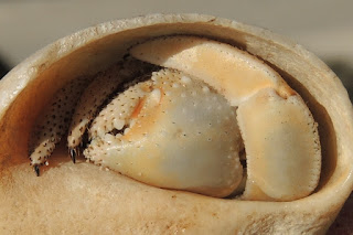
On capture, terrestrial hermit crabs can be quite feisty and will attack fingers, even though they have to come along way out to do so.  If they feel threatened, they pull back into their shells and block the entrance with their nippers and legs, something that marine hermit crabs can't do.  Marine hermit crabs are timid in comparison.
Australian hermit crab
Terrestrial hermit crabs are not shy
Terrestrial hermit crab nipper
Terrestrial hermit crabs can also seal the door with their legs.  
Terrestrial hermit crabs feed on a variety of things but probably eat mainly vegetation.  In captivity, they readily eat the vegetables that people eat.  In the wild, I was only able to observe them eating an old mangrove dropper (Rhizophora stylosa propagule)

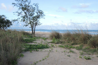
Coastal grassland hermit crab habitat
Typical seaside grassland habitat
Coenobita variabilis habitat
Laterite and beach rock shelves on beaches also provide foraging areas. 

Coenobita variabilis feeding
Hermit crabs feeding on mangrove propagule

Hermit Crabs as Pets

When it comes to invertebrates, I think that hermit crabs are one of the best choices there is.  They live up to 10 years, which is longer than almost all insects.  They are also quite active and move around on the surface, unlike many insects which bury themselves in soil as soon as they get a chance.  Insects can also be very robotic with a very limited set of behaviours.  In contrast, hermit crabs seem to explore their enclosures and active hide from us when we get close.  They pull back into their shells and roll down of what ever object they were climbing or try to run under something. They also try to burrow under their water bowl and will climb up anything and will swing from the roof of their enclosure if they get the chance.

Hermit crabs can't tell us how they feel so we have to look for indirect signs of whether they are happy to be pets.  So far, I have only had to release one invertebrate because it was so desperate to escape that it was not worth keeping and that animal was a red claw (Cherax quadricarinatus).  Most insects are clearly not worried about being contained provided they have food, water and mates.  If invertebrates are unhappy, they tend to lurch around their enclosures constantly.  I think that hermit crabs are on the verge of intelligence and require some additional care to make their enclosures interesting.  Hermit crabs also require warmth and fresh and saltwater.  They are very easy to feed, eating many human foods.  They also like the company of their kin and lots of empty shells to try out. Give them what they want and they will be happy.  People are crazy for hermit crabs and there are many pages with good advice on keeping them.


Saturday, 25 April 2015

Cairns' Disappearing Mudflats

The famous Cairns mudflats are almost no more. This muddiest of places and magnet for migrating wading birds is becoming a sand flat. Some people think that the Council’s efforts to make a sandy beach is responsible for the gradual loss of this internationally important shorebird feeding area.  Certainly the amount of sand being placed on the esplanade should be investigated, however other factors might be at play including cyclones and coastal processes. 

Cairns' fine man made beach
Cairns is one of a very few places where you can sit on a boardwalk and view a dozen or more species of usually shy wild birds feeding only metres away. The birds can’t afford to be shy as there are few good feeding grounds in either direction. I once commissioned professional ornithologists to study one of the major estuaries to the north of Cairns. Port Musgrave on Cape York Peninsula should be ideal wader habitat. However we found that when the waders are migrating, it was always high tide during the day so the waders could not feed there. It takes a special set of circumstances to create good wader habitat. 

A wading bird less than 10 m from my seat and feeding in the small remaining muddy area near the birdwatchers lookouts.
The rich wader habitat in Cairns may also be partly of human creation. The shape of the coastline has been changed due to developments like the Pier and this has created a poorly flushed area which is great for accumulating mud deposits. Long before the Pier arrived, Fogarty Park which juts out into the estuary had been reclaimed. In the Cairns hinterland, land clearing was at its peak and there was much less concern for soil erosion at the time. Sediment supply from the Barron River, Trinity Inlet and even Saltwater Creek near the airport would have been much greater. Saltwater Creek now only drains urban areas, but when I was young this area was cane fields and would have yielded more sediment. The local Port Authority also pulls out all the mangroves which are attempting to colonise the mudflats just off the esplanade. This creates an open muddy habitat in an area that would normally be a dense mangrove swamp. Harbour dredging in times past would have had less consideration for sediment plumes and many think that these are the source of the Cairns mudflats.  Historically, Cairns is said to have had a sandy beach. However in my imagination, the sandy beach would have risen above a mudflat as in Cardwell today. This was the case in aerial photos from 1952.

Another wader feeding on the lumpy mud-scape near the wading pool - where the mud builds up today
I have been trying to establish a time series photographic record to make the changes over time visible. Unfortunately, nobody expects a fact of life such as the Cairns mudflats to disappear, so there is not much in the way of old data. However it is obvious that at least in some places, the mudflats are becoming sandy as you can now walk out a long way without sinking up to your knees. The question is where is the sand coming from and/or where is the mud going.  Similar changes are also occurring at Ellie Point which extends from northern end of the Esplanade. If massive changes have been taking place even quite far away from the sandy beach where the council dumps sand, it suggests other factors are involved. 

Dredge working in the shipping channel - note lack of life on exposed tidal flats which occupy the bottom half of the photo .
An almost matching view from 2005.
Telephoto view of the flats - the black object is a beer bottle (2014)
The same area in 2005 was seething with life 
The full story is complex and I am only undertaking informal investigations. It is probable that there is less mud coming out of the rivers. Even the sea on the Cairns Northern Beaches is more blue than brown these days. It used to be the colour of milk coffee in rough weather. Sand supply has also increased due to banning of sand mining in the Barron River and at Ellie Point. This supply which is estimated to be 23 000 tonnes a year is beginning to pour around the tip of Ellie Point. The renewed supply of river sand could already be making a minor contribution to the sand supply on the esplanade. Cyclones may have had a bigger impact. At Cardwell, Yasi washed away vast volumes of surface mud and left only the heavier sand. Several big cyclones have passed close to Cairns in recent years.  It is the swells that they generate that do the damage and these swells can change our coastline even when the cyclone is hundreds of kilometres away by creating inshore currents and by lifting sediment into the water column. Cyclones have always been around but there has been less time between large events recently.

In 2005, seagrass beds were clearly visible from the Esplanade (the dark band).  They appear to have disappeared from most of the Cairns foreshore.
The gradual loss of large areas of mudflat from Cairns probably has multiple causes and it would take a lot of work to apportion blame. If you are interested in helping to figure out what is happening leave a comment.  All the photos here were taken from near Muddies Playground.