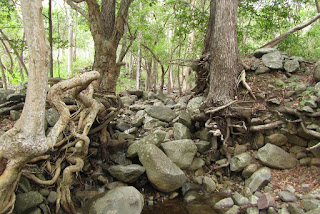
Friday, 8 April 2016

Fauna in the Swash Zone of a Tropical Beach

Swash is the foaming surge of water that runs up the face of a beach after a wave breaks.  This narrow habitat has its own distinct fauna, a fauna which is well documented in cold countries that have lots of beaches but is almost undocumented in the tropics where people tend to focus on corals and mangroves. 


Low tide terrace of Yorkeys Knob Beach is prime swash fauna habitat, even for mole crabs
The swash zone is full of life and has many species that are not found on sand flats that are exposed at low tide.  On a remote beach, I once grabbed a handful of sand and counted 17 pipis of varying sizes in that single handful.  Here is a video that shows migrating pipi, filter feeding worms, a common moon crab and pied oystercatcher feeding on pipi.


Each beach has its own wave and sand characteristics and the fauna present vary greatly.  In North Queensland, there is a spectrum of beaches from steep beaches with coarse sand and almost flat beaches with fine sand.  The best beaches for fauna are the beaches between the two extremes.  Most of the swash fauna migrate up and down the beach with the tides, probably to escape predation.  When a beach is very flat, the distances between high and low tide swash zones becomes very far and the swash becomes so slow and gentle that it does not liquefy the sand.  Most of the migrating swash fauna also need the sand to be mobilised or liquefied by waves so that they can burrow into it.  Burrowing into hard packed sand is very difficult for many creatures.  At the other end of the spectrum are steep beaches with coarse sand where waves crash down hard on bare sand.  Very little fauna can be found in these beaches.  Beaches that do not have swash such as beaches within river mouths also do not have much fauna.
Swash zone fauna do not like waves that crash down on the beach
Pipi (officially called Cuneate Wedge Shells – Donax cuneatus) are the best know inhabitant of the tropical swash zone.  People dig them up and take them home to fry, spice and eat.  Pipi came to be of interest me when I noticed that they eject themselves from the sand so that waves can carry them up the beach.  On my favourite beach, the slope is steep and the swash moves very quickly so the pipi have to be very decisive about which waves to catch and with regard to timing.  Everything is so fast that it too fast for human vision and I resorted to using high speed video which is how I saw that pipi sometimes jump out of the sand microseconds before or after the arrival of the wave.  Now I have found out that pipi move in a much more relaxed fashion on shallow sloping beaches and can easily be observed with the naked eye.  The gentler swash on these beaches do not always move the pipi far enough and the pipi somehow know!  They just lie there on the surface waiting for another wave.  Sometimes up to 3 waves are needed to move the pipi up the beach and make it happy.  Then it wiggles its foot vigorously into the sand and pulls its shell down before the wave retreats and the sand goes hard.  Very occasionally, a pipi will be taken too far up the beach and they just wait for a big wave to take them back down again. 
Donax cuneatus, Yorkeys Knob
Pipi (Cuneate Wedge Shell, with foot and siphons exposed
Pipi can use their siphons like arms to push into the sand and hold themselves against the retreating swash.  They also use their foot to dig into the sand like an anchor, however I think as swash usually undermines the sand out from beneath my feet, that the foot of the pipi mainly perform a hydrodynamic role and prevent the sand from being undermined from under the pipi. 
Much rarer than pipi are mole crabs.  I have only ever caught one.  They are neither common or easy to find.  Mole crabs filter feed with their antennae.
A mole crab - Albunea-symmysta
The entire undersurface of Albunea is dedicated to digging implements
Feeding Albunea poke their antennae into the retreating swash
On beaches with fine sand, tiny filter feeding worms are the most common creatures and they cover the entire surface of the beach.  These worms have burrows where they can wait between tides rather than migrating.  Finding out what the worms are called is a mission as almost nobody writes about these creatures even though they are so common that they must be ecologically important.  I think that they may be a type of palp worm (Spionidae).
Head and palps of filter feeding worms, click to enlarge as they are hard to see

The filter feeding worms are quite small
However the spionid? worms cover the beach
Matuta victor crabs patrol within the surging swash.  There seems to be a Matuta crab every few metres, which is a similar density to ghost crabs which scavenge the beach at low tide.  Matuta are reported to eat bivalves and worms so are probably the primary predators of the pipi and spionid worms. 
Common Moon Crab - Matuta victor
Fish are also present within the swash.  Fourline Striped Grunter, Pelates quadrilineatus zoom around in the swash.  A few times I saw a small sole allowing itself to be beached as the swash retreated.  It could see me coming and always escaped.

When the tide retreats, the swash zone also provides food for ghost crabs and pied oystercatcher.

Pied Oystercatcher feeding on Wedge Shells
Baby horn-eyed ghost crab
There are probably several creatures present within the swash zone waiting to be discovered. With waves constantly moving everything around, it is a very difficult place to study.


Shrimp dug up in swash zone


To find information in this blog please use the subject index

Sunday, 3 April 2016

The Secret Power of Ordinary Coastal Processes

For a long time geomorphologists (people who study how landscapes evolve) thought that is was mainly day to day coastal processes that shaped our coastline.  Then came a realisation that many coastal features were in fact created by major events from super cyclones to tsunamis.  Major events then became the main focus of study.  But there seems to be another agent of change that possibly has as much effect as major events and this is synergies of ordinary events.  In more than twenty years of observations of the Cairns Northern Beaches, these synergies have caused more beach erosion than several major cyclones. In this post and a future post, I will describe two synergies that can move vast amounts of sand in periods of hours.


One of most dynamic sections of coastline near Cairns is Barr Creek, which lies between Machans Beach and Holloways Beach.  This tiny little creek is only 1.2 km long, yet it can turn ordinary tides into dramatic events.  Barr Creek is unlike all of the other creeks in the region as it is an ancient abandoned mouth of the Barron River.  The other creeks have catchments on side the mountain ranges and their channels are maintained by flooding rains draining back to the sea.  Barr Creek barely has any catchment at all, just fringing mangrove swamps.  In theory, when turbid seawater fills into the Barr Creek at high tide, sediment should settle out of the still water and rapidly fill the creek in.  This is exactly what happened in the nearby Blind Barron, a mouth that was abandoned approximately 70 years ago.  Yet Barr Creek maintains itself.

The mouth of Barr Creek migrates from side to side
Most of Barr Creek can be seen from the beach
Barr Creek 1 km upstream is almost too small to turn a small boat
Barr Creek's secret is that it has flood-like outgoing tides.  No other creek in the region has these.  I suspect that on highest astronomical tides (~3.3 m), seawater expands over an almost flat ground surface in areas with mangroves and salt pan.  As tides get higher, the area that is flooded increases exponentially and the volume of water in the Barr Creek estuary would be much greater for an extreme high tide than a normal high tide.  When the tide turns, all of that extra water has to squeeze out of a creek mouth that is always being narrowed as longshore drift fills the mouth with sand at a rapid rate.  Longshore drift occurs when trade wind driven waves strike the beach at an angle and their swash pushes sand along the beach.  On the outgoing tide, waters flood out through the narrowed mouth at high speed creating standing waves that can be more than a metre high.  Ocean swells also force their way up into the outgoing flood and momentarily transform standing waves into raging peaks of water as they pass.  When conditions were like this we used to drop everything and go white water rafting (the video does not show a full power day).  After the flood has surged more than one hundred metres out to sea it plunges through a rolling wave than marks the end of the flood and the start of the sea.

Underneath the surface the outgoing flood is a turbulent maelstrom.  The sandy bottom is not smooth but a complex pattern of mega ripples and swirling vortexes that vacuum sand of the bottom and inject it into the flowing water.  A single tide can transport enough sand to create an alluvial fan that extends 100 m into the sea and which would require more than 2500 tonnes of sand by rough calculation.  A continually rolling wave is located at the seaward edge of the alluvial fan.  Inshore waters are shallow so the alluvial fan ends with a steep drop of only half a metre.

Strong longshore drift removes the alluvial fan within a few days to weeks.  The same longshore drift brings new sand to the creek mouth where it is sucked up the creek to form an alluvial fan that faces upstream.  Sand accumulated in the creek mouth in this way provides material for forming a fan in the sea when the tide runs out.

Aerial view showing both alluvial fans.  The fan in the sea is 85 m long and is mainly from one tide.
It is amazing how big the alluvial fans can get.  At the front-left are a few mega-ripples
Beaches often seem to be static places, adjusting only slowly to the balance between accretion and erosion, however the truth is that every wave moves more sand than a good man can shovel in a minute.  Usually the amount of sand added and removed is in balance.  It is only in special places where sand movements are not balanced that true level of movement is revealed.

Kids love the high banks where the creek cuts into the beach
Getting rolled along by the incoming tide is fun too!
There is a funny side to the Barr Creek tidal movements.  Years ago Holloways Beach had a pub and Machans did not.  So people would come across the creek at low tide then go home in the dark.  At night you can’t see power of the water or its depth.  Many people have been swept away attempting to cross the creek.  Lucky they could all swim.  The incoming tide is pretty nasty too and some people got swept up the creek into the mangroves and you can imagine the fun: drunk in the dark and staggering through the mangroves.

On a particularly violent day when outgoing tide was reinforced with a freshwater flood, I was out there having fun when a rescue helicopter came out and started circling around me.  I was trying to surf the standing waves on a competition surf ski which can be paddled to about 15 km/h.  But the water was much faster and I would paddle upstream like mad whilst getting sucked backward through the flood until I caught a standing wave and hopefully surfed.  Of course you can’t see what is coming when you are going backwards which makes it very exciting and it is almost impossible to go through the roller backwards without coming off.  Beyond the roller is flat calm sea so you just get back onto the surf ski, paddle to the beach and go again.  Of course the rescue helicopter shows up just at the point of wipe out and thinks I am in trouble and started preparing to rescue me, which was embarrassing.

Barr Creek mouth widened to 60 m after a cyclone when Barron River water flowed through fields into Barr Creek 
In this post I have talked about how a synergy of ordinary events can create very powerful forces.  In a future post, I will show the damage this process can do when it combines with other ordinary events to create an extra-ordinary synergy.

For more information on coastal processes, see the subject index

Monday, 28 March 2016

Coastal Grasslands near the Tip of Australia

Behind the mangroves of the great inlets of Western Cape York Peninsula are vast grasslands that can be a few kilometres wide and many kilometres long.  This post shows a grassland at Port Musgrave and some images of Unigan nature reserve in Weipa.

View across grassland toward paperbark woodlands on far side
Looking toward bauxite plateau over a sward of salt tolerant sedges (click to enlarge)
These grasslands, which are also known as marine plains, form an extended transition between sea and land.  Marine plains have an imperceptible slope, descending at 1 m per kilometre from landward edge to mangrove edge.  Within the plain, the vegetation gradually changes from seasonal freshwater wetland to saline marine flats.

Tea tree sapling in blady grass on a marine plain, Port Musgrave
View of wet blady grass flats near bauxite plateau with mangroves in distance
The grasslands are both spectacular and a challenge to the senses.  Their great uniformity offers no secrets and it is tempting to leave after a few minutes.  Yet this is a unique and productive ecosystem and if you can adjust your perception, there are things to be seen and environmental lessons to be learned.  People used to live in these areas, how did they survive?

The dangers of these areas that needs to be considered before setting out to experience them.  Savage feral cattle which were set free in this area over a century ago and without much parasite resistance, are crankier than modern cattle.  Feral pigs seek out the best patches of wetland and turn them into hectares of muddy slosh.  After walking through these areas I needed treatment for hook worms, which created thin itchy trails of blood beneath my skin.  The well-known threats of crocodiles and snakes are probably less of an issue here than elsewhere as they are not easily found even when searched for.  In the dry season fire is a serious risk.  When all of Cape York Peninsula is on fire, the air becomes thick with smoke and distant views are lost.  Fire is often out there but you don’t know exactly far away it is, so it pays to have firm ideas of how to escape in the event.  I have not seen a grassland burn, but I imagine it makes its own winds and would be a fierce unpredictable hazard.  Most grasslands are burnt annually.  Finally during the wet season, grass swamps can be heat traps where the air is still and humidity reaches 100%.  In the worst conditions, human endurance is about ten minutes.  Even dark still waters can become so hot that they are above the threshold of pain.  Warning over, lets continue.

Feral short horn bull, Port Musgrave
These things are more of a health hazard than crocs
Surrounding the inlet is a thin band of mangroves.  A single high tide every 24 hours (not two as is normal) would not provide enough flushing to keep dry season salinity down.  The neap tide-spring tide cycle would leave many areas to dry out for weeks on end.  It is very saline close to the inlet. The inner edge of the 100 m wide mangrove fringe has a strange thicket of club mangroves with swollen stems and salt encrusted leaves.  In a few places tall succulent shrubs are present, which resemble cactus with fine branches.

Mangrove fringe, Port Musgrave
Mangrove fringe around inlet showing zonation of species with increasing salinity.
Inner edge of mangrove fringe has a thicket of club mangroves (Aegialitis annulata

Chenopod shrubland on marine plain, Port Musgrave
Small areas have unusual shrublands with 1 m high succulents (Tecticornia indica)
A narrow saltpan separates the mangroves from the grasslands.  Soils in this area are swelling-cracking clays.  These black clay soils which are normally found in inland areas swell greatly when wet and conversely shrink and crack deeply when dry.  Few tree species can endure this type of ground movement.  Well below the the low ridge that marks the limit for regular spring tides, there is a strange grassland which must flood with seawater many times each year.
Xerochloa imberbis grassland, Port Musgrave
Xerochloa grassland fringed with Batis.  Mangroves in distance
Cracking soil of a marine plain on Cape York Peninsula
Large cracks let the soil dry out
Closeup of green Xerochloa imberbis stems
Xerochloa imberbis has tiny leaves and mainly uses stems for photosynthesis
Landward of the king tide ridge lies a broad sedge flat.  The heaving of the soil probably creates small round Gilgai wetlands in which Chinese water chestnuts (Eleocharis dulcis) grow.  Pigs seek dig up many of these wetlands and may have even created a simple agricultural system, where they deepen and improve the swamps that grow their food.  Humans can eat the tubers as well and they taste great, raw or cooked.
Chinese water chestnut in natural habitat
A large spring-fed drainage line with Eleocharis reeds and stunted mangroves.  
Despite heavy rains, drainage lines in the grassland are tiny or non-existent across most of the grassland.  Rain would have to drain across flat ground through decomposing vegetation and even dense beds of aquatic plants that spread below the grass.  Before the water could drain, more rain would have fallen keeping the area wet for months on end.  In the dry season, the flatness and impervious clay soil ensure that once the surface moisture is gone, drought will commence suddenly and be unrelenting.  This is an ecosystem that switches between being waterlogged and drought stricken.

In bauxite areas, freshwater seeps out of springs and into the grasslands from the base of the jump-up that separates marine plain from bushland.  Until the beginning of June, these areas have lush grasslands, with grass taller than a man.  Then in August/October, these areas burn.  The total loss of vegetation is hard for small wildlife to cope with and the area has many pigs and dingoes, both of which are major predators so there is very little wildlife even frogs.  Poor nutrient status of the soils probably also contributes to the scarcity as even cattle do not thrive here.

Panicum trachyrhachis grassland
Panicum trachyrachis wet grassland
Wet grassland, Cape York Peninsula
Floating Azolla fern, bladderworts and other species form an aquatic understorey 
Burned grass stems on marine plain
Stems of grassland burned before completely dry (~August)
In Unigan Nature Reserve, which is near Weipa, signs of the original aboriginal people who lived grassland-mangrove boundary remain.  They ate cockles in vast quantities and discarded the shells form huge heaps which rise above the grasslands like artificial islands.  Native fruit trees provide shade.  How they fished for cockles in the crocodile capital of Australia and how they survived nights with mosquitos that drill into bone, I think those secrets are lost.

Close up of cockle shells
Cockles were on the menu
Heritage-listed cockle shell mound near Weipa
One of the heritage-listed shell mounds that is in the middle of a grassland and close to the mangroves


Tuesday, 15 March 2016

Largest Landslide in Australia

The Captain Cook Highway, which runs from Cairns to Port Douglas is an iconic coastal road, yet it has a violent geological past that has too soon been forgotten.  Torrents of stone and mud have periodically transformed the landscape with the most recent event permanently burying parts of the original highway.  In some places where the current highway veers away from the beach, it is actually crossing over debris fields deposited in part by an immense recent landslide.  The primary historical record for this event appears to be a small Cairns Post article from Monday 15 January 1951 which reported:
“It will cost the Main Roads Commission many thousands of
pounds to repair a six-mile stretch of the Cook Highway between
Buchan and Simpson's Points, following huge landslides caused
by a torrential downpour lasting nearly five hours.
Almost unbelievable quantities of earth and debris were swept
from the mountain-side down on to the roadway and over the
precipice into the sea. Gigantic trees were uprooted and ground to
pulp, and boulders as high as 10 feet hurled into the Pacific- as if
they were marbles.
Millions of gallons of water cascaded down the mountains into
the sea, gouging huge ravines and making swiftly running streams
in the thousands of tons of earth and rubble left on the road in the
wake of the slides.”
Why are there no detailed records of the most violent landslide in Australian recorded history? Despite being in living memory and cutting the highway to Port Douglas for a few weeks, finding a photograph of this event or even a map of where it occurred seems to be impossible.  I have been trying to piece together what happened for a few years now and the story just gets bigger.

Near Cairns there are a number of places which are prone to these massive events, which could be up to 1000 times larger than the tragic Thredbo landslide.  These events could cause serious loss of life and property and there needs to be less complacence about this issue.

Approximately 2 km north of Ellis Beach are a few pretty sandy beaches with boulder headlands at each end.  A further 1.5 km north there is a boulder beach that is 3.5 km long.  The origin of the boulders on this mostly ignored stretch of coast is the subject of this post.  The native bedrock of this coastline is a slate-like metamorphic stone whereas the boulders are granite so it is clear that the boulders came from somewhere else.  These boulders provide a means of tracing the debris flows back to their origins.

Coastline with round granite boulders
A boulder beach near Ellis Beach in Far North Queensland (Click to enlarge)
For a moment lets stay at the boulder beach.  Relative to surrounding coastlines, it is a biological desert.  There are no oysters, barnacles, macro-algae and very few limpets and grazing gastropods.  I saw some trails in the sand from nerita snails, which is odd as they normally live on rocks. Perhaps the grazing snails which should be present in countless millions are being knocked off the smooth stones by waves.  Even under the rocks, there is hardly any life.  The round shape of the rocks means that even a large stone provides almost no shelter below.  I do not think that the rocks roll around in normal rough weather, this coast is a sheltered coast and the stones are very large being from 50-80 cm.  The slope of the beach is also very low and would gradually dissipate wave energy.  In contrast, at a nearby steeply sloping, south-east facing beach with 20 cm cobbles, it is possible to hear and feel vibration from rocks being tumbled around in the 1.5 m beach break.  On the boulder beach, I think that polishing by sand and lack of shelter from the elements makes this environment so hostile to marine life.  Large boulders that stand further out to sea have the expected level of life.  On the boulder beach, the only notable lifeforms were the strange black rings of blue-green bacteria, which are a stone-like encrustation.  The rocky shore of Island Point which was covered in a recent post makes an interesting comparison.
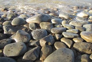
Almost lifeless boulder beach
Sand polished boulders near low tide level
In Google Earth, you can see that there are many small creeks flowing down the coastal escarpment and each appears to have delivered stone to the coast.  Between the creeks are hard metamorphic hills which constrain the positions of the creeks and hence direct the flow of stone.  All of the boulder headlands have formed in the mouths of creeks.  Between the creeks are very steep hill faces that press against the beach.  These slopes may look like an obvious source of stone but inspection reveals that these metamorphic hills make very little contribution.

Aerial view of Simpsons Point
Landslide debris creates headlands on Captain Cook Highway
Simpsons Point from the side, showing boulders pushed into the sea by a debris flow
In the aerial photo near the highway are patches of dark green forest.  These forests grow on debris fans that have spread out and settled before hitting the sea.  Pockets of dry rainforest find protection from fire in rock-rich debris fans.  Close to the top of the aerial image, is a potential source of stone as the bedrock switches to granite part way up the 700 m tall coastal escarpment.  Small areas of bare rock slab can be seen.  Granite begins 250-350 m above sea level and approximately 750 m from the sea when measured horizontally.  That is a long way for thousands of tonnes of stone to move.  Some of the largest boulders that can be seen from the highway are nearly 8 m in diameter.  Evidence for how the stone moved so far is best found by following the small creeks up toward their origins.

While most debris fans have dry rainforest, the debris fan in the catchment explored in this post had a glade of cycads that was more than 100 metres across.  Cycads are at their best in rocky ground.

Cycad understorey in eucalypt woodsland
The glade of cycads
Climbing up toward the top of the debris fan, the rock content of the soil became more obvious.  Between the rocks are seasonal herbs such as hibiscus (H. meraukensis) and Polynesian arrowroot (Tacca leontopetaloides).  At the edge of the debris fan, the vegetation of the glade suddenly gives way to the vegetation of metamorphic hills; ironbark and kangaroo grass woodland.

Herbs that spring up from bulbs during the wet seasons fill spaces between the cycads
Ironbark woodland
Ironbark woodlands cover metamorphic hills beside the old debris flows
Beneath the woodland vegetation is a thin skeletal soil over solid metamorphic stone.  On some of the steeper slopes, the rock is so close to the surface that grass cannot grow, though trees can exploit cracks between the vertically tilted layers to obtain what they need.  With time and weathering metamorphic reluctantly breaks down into flakes of rock and then clay without producing boulders.  Only when competent metamorphic bedrock is exposed by rivers and streams does this rock form boulders.  Initially the boulders are blocky but with time the edges are worn away.  Yet the boulders nearly always retain flat surfaces in contrast to granite which forms round stones.

A naturally bare patch showing metamorphic rock fracturing and flaking
Solid metamorphic rock lies below the surface
Above the debris fans, the creeks follow deep gullies incised into metamorphic bedrock.  Debris flows are not as nimble as water and rather than flowing down the watercourse, they tend to fill it up like a glacier.  A creek which was 5 m wide may be filled with a stream of stone and earth over 50 m wide.  At the centre of the debris flow, the deposited material may be 4-6 m deep.  Stream waters have to find a new way down the gully and usually form new channels on either side of the debris flow.  Between these channels, the consolidated debris flow becomes a raised strip of bolder strewn forest which develops its own distinct vegetation.  When stream waters erode the edges of the debris flow, they create vertical faces that allow the depth and make-up of the debris flows to be examined.

Cardwell lilies
Cardwell lilies fill the understorey on the new forest in the gully
Unaltered material from the stalled debris flow
Red earth and stone between the tree roots show the original character of the debris flow
Fresh landslide debris would contain as much earth as stone, but over time the earth washes away, leaving only the stones.  Trees which have grown on the landslide debris end up with roots looping trough the air as the ground settles and washes away.  Interestingly the remnant debris flow contains a red earth that appears to be of metamorphic origin, and not decomposed granite or sandy clay which is associated with granite boulders that form in situ.  This mix of geologies suggests a mechanism for these massive landslides.

A contact zone slip plane with a layer of weathered metamorphic rock resting on top
The mountains beside the Cook Highway formed when magma rose up into cracks that formed in the deep deposit of ocean sediments at a time when the east coast was under tension.  The sediments were cooked into metamorphic rocks and the magma solidified to form granite.  All granite forms at least two kilometres below the surface and is then uplifted, however usually the stone into which the granite intruded has long eroded away leaving only the granite geology.  Along most of the Cook Highway, the granite is still in the process of losing its cover of metamorphic rock.  Between the metamorphic rock and the granite is a contact zone which is a hard, almost mirror smooth surface probably composed of melted marine sediment.  These surfaces are steeply sloping and are hundreds of metres long.  There is no more perfect slip plane.  At the top of the mountain is exposed granite, which weathers in the usual fashion and creates boulders.  They mystery is how hundreds of thousands of tonnes of earth and boulders suddenly become mobile and I don't really know so I am going to speculate about what I think happens.  The slope is approximately one in three, which from my carefully conducted experiments of rolling rocks down slopes, is the steepest slope where rolling rocks are more likely to come to rest than keep rolling.  Usually they come to rest after after hitting an obstacle or a few inefficient end over end tumbles.  Many boulders created by weathering of granite outcrop might roll down until the collide with trees or terrain and collect on the mid-slopes of the range which have metamorphic soils.  Soil and small stones washed down from the kilometre long slopes above the exposed rock faces may also build up over time on the rock faces, creating landslide fuel for the future.
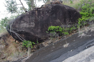
Giant boulder resting on steep slope
A big rock that almost kept rolling
red earth on a steep slip plane
A wedge of soil on a slip plane. The slope in the foreground probably shed its load.
In deducing the mechanism for these landslides, It would really help to know where the landslide originated, above the mid-slope granite exposures or below?  Unfortunately, it does not appear that this information was recorded for the 1951 debris flow.  Geosciences Australia  (GA) in their report titled Quantitative Landslide Risk Assessment of Cairns (AGSO RECORD 1999/36) estimates that the landslides described in this post brought down between 180 000 and 720 000 tonnes of material and buried sections of highway to a depth of 3 m.  GA consider that the rainfall event that triggered this landslide has a return interval of about 400 years, however that does not factor in climate change.  The key issue may also be accumulation of material over a slip plane rather than rainfall and the rate of this process was not  estimated in the report.  I would think that the return interval for large landslides could be in the order of 100-200 years.

When the ground does let go, the one thing that is certain is that the debris flow hurtles down the gullies.  Beside the small creek I followed, the debris flow averaged 30 m wide and formed an elevated inclined plain.  It is likely that nearly all the trees present in the gully would have been ripped from the ground and carried away.   Occasionally, when a few large trees formed a row across the gully, they were able stand against the debris flow.  These trees by virtue of their being there to halt part of the debris flow provide indirect evidence that the flow occurred decades ago, not hundreds of years ago.  In many places the sides of the gully were scoured back to bedrock.  The evidence shown here is repeated in most of the creeks on this section of coastline.  On some of the larger and most damaged creeks, the vegetation has not recovered.  When the trees were destroyed, tall exotic grasses and lantana moved in to form a blanket of weeds that have suppressed the regeneration of forest.
The sloping surface of the old debris flow occupies the middle of the gully
A few trees stood against the onslaught and built a wall of rocks
Burdekin plum tree (Pleiogynum timoriense) on debris field.
The tree on the right has roots at two levels showing that it has seen 2 debris flows.