The Captain Cook Highway, which runs from Cairns to Port Douglas is an iconic coastal road, yet it has a violent geological past that has too soon been forgotten. Torrents of stone and mud have periodically transformed the landscape with the most recent event permanently burying parts of the original highway. In some places where the current highway veers away from the beach, it is actually crossing over debris fields deposited in part by an immense recent landslide. The primary historical record for this event appears to be a small Cairns Post article from Monday 15 January 1951 which reported:
“It will cost the Main Roads Commission many thousands of
pounds to repair a six-mile stretch of the Cook Highway between
Buchan and Simpson's Points, following huge landslides caused
by a torrential downpour lasting nearly five hours.
Almost unbelievable quantities of earth and debris were swept
from the mountain-side down on to the roadway and over the
precipice into the sea. Gigantic trees were uprooted and ground to
pulp, and boulders as high as 10 feet hurled into the Pacific- as if
they were marbles.
Millions of gallons of water cascaded down the mountains into
the sea, gouging huge ravines and making swiftly running streams
in the thousands of tons of earth and rubble left on the road in the
wake of the slides.”
Why are there no detailed records of the most violent landslide in Australian recorded history? Despite being in living memory and cutting the highway to Port Douglas for a few weeks, finding a photograph of this event or even a map of where it occurred seems to be impossible. I have been trying to piece together what happened for a few years now and the story just gets bigger.
Near Cairns there are a number of places which are prone to these massive events, which could be up to 1000 times larger than the tragic Thredbo landslide. These events could cause serious loss of life and property and there needs to be less complacence about this issue.
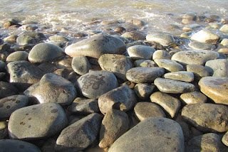
Approximately 2 km north of Ellis Beach are a few pretty sandy beaches with boulder headlands at each end. A further 1.5 km north there is a boulder beach that is 3.5 km long. The origin of the boulders on this mostly ignored stretch of coast is the subject of this post. The native bedrock of this coastline is a slate-like metamorphic stone whereas the boulders are granite so it is clear that the boulders came from somewhere else. These boulders provide a means of tracing the debris flows back to their origins.
 |
| A boulder beach near Ellis Beach in Far North Queensland (Click to enlarge) |
For a moment lets stay at the boulder beach. Relative to surrounding coastlines, it is a biological desert. There are no oysters, barnacles, macro-algae and very few limpets and grazing gastropods. I saw some trails in the sand from nerita snails, which is odd as they normally live on rocks. Perhaps the grazing snails which should be present in countless millions are being knocked off the smooth stones by waves. Even under the rocks, there is hardly any life. The round shape of the rocks means that even a large stone provides almost no shelter below. I do not think that the rocks roll around in normal rough weather, this coast is a sheltered coast and the stones are very large being from 50-80 cm. The slope of the beach is also very low and would gradually dissipate wave energy. In contrast, at a nearby steeply sloping, south-east facing beach with 20 cm cobbles, it is possible to hear and feel vibration from rocks being tumbled around in the 1.5 m beach break. On the boulder beach, I think that polishing by sand and lack of shelter from the elements makes this environment so hostile to marine life. Large boulders that stand further out to sea have the expected level of life. On the boulder beach, the only notable lifeforms were the strange black rings of blue-green bacteria, which are a stone-like encrustation. The
rocky shore of Island Point which was covered in a recent post makes an interesting comparison.
 |
| Sand polished boulders near low tide level |
In Google Earth, you can see that there are many small creeks flowing down the coastal escarpment and each appears to have delivered stone to the coast. Between the creeks are hard metamorphic hills which constrain the positions of the creeks and hence direct the flow of stone. All of the boulder headlands have formed in the mouths of creeks. Between the creeks are very steep hill faces that press against the beach. These slopes may look like an obvious source of stone but inspection reveals that these metamorphic hills make very little contribution.
 |
| Aerial view of Simpsons Point |
 |
| Simpsons Point from the side, showing boulders pushed into the sea by a debris flow |
In the aerial photo near the highway are patches of dark green forest. These forests grow on debris fans that have spread out and settled before hitting the sea. Pockets of dry rainforest find protection from fire in rock-rich debris fans. Close to the top of the aerial image, is a potential source of stone as the bedrock switches to granite part way up the 700 m tall coastal escarpment. Small areas of bare rock slab can be seen. Granite begins 250-350 m above sea level and approximately 750 m from the sea when measured horizontally. That is a long way for thousands of tonnes of stone to move. Some of the largest boulders that can be seen from the highway are nearly 8 m in diameter. Evidence for how the stone moved so far is best found by following the small creeks up toward their origins.
While most debris fans have dry rainforest, the debris fan in the catchment explored in this post had a glade of cycads that was more than 100 metres across. Cycads are at their best in rocky ground.
 |
| The glade of cycads |
Climbing up toward the top of the debris fan, the rock content of the soil became more obvious. Between the rocks are seasonal herbs such as hibiscus (
H. meraukensis) and Polynesian arrowroot (
Tacca leontopetaloides). At the edge of the debris fan, the vegetation of the glade suddenly gives way to the vegetation of metamorphic hills; ironbark and kangaroo grass woodland.
 |
| Herbs that spring up from bulbs during the wet seasons fill spaces between the cycads |
 |
| Ironbark woodlands cover metamorphic hills beside the old debris flows |
Beneath the woodland vegetation is a thin skeletal soil over solid metamorphic stone. On some of the steeper slopes, the rock is so close to the surface that grass cannot grow, though trees can exploit cracks between the vertically tilted layers to obtain what they need. With time and weathering metamorphic reluctantly breaks down into flakes of rock and then clay without producing boulders. Only when competent metamorphic bedrock is exposed by rivers and streams does this rock form boulders. Initially the boulders are blocky but with time the edges are worn away. Yet the boulders nearly always retain flat surfaces in contrast to granite which forms round stones.
 |
| A naturally bare patch showing metamorphic rock fracturing and flaking |
 |
| Solid metamorphic rock lies below the surface |
Above the debris fans, the creeks follow deep gullies incised into metamorphic bedrock. Debris flows are not as nimble as water and rather than flowing down the watercourse, they tend to fill it up like a glacier. A creek which was 5 m wide may be filled with a stream of stone and earth over 50 m wide. At the centre of the debris flow, the deposited material may be 4-6 m deep. Stream waters have to find a new way down the gully and usually form new channels on either side of the debris flow. Between these channels, the consolidated debris flow becomes a raised strip of bolder strewn forest which develops its own distinct vegetation. When stream waters erode the edges of the debris flow, they create vertical faces that allow the depth and make-up of the debris flows to be examined.
 |
| Cardwell lilies fill the understorey on the new forest in the gully |
 |
| Red earth and stone between the tree roots show the original character of the debris flow |
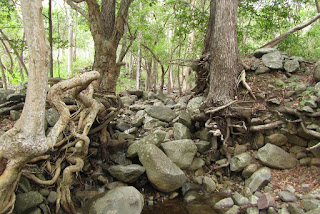
Fresh landslide debris would contain as much earth as stone, but over time the earth washes away, leaving only the stones. Trees which have grown on the landslide debris end up with roots looping trough the air as the ground settles and washes away. Interestingly the remnant debris flow contains a red earth that appears to be of metamorphic origin, and not decomposed granite or sandy clay which is associated with granite boulders that form in situ. This mix of geologies suggests a mechanism for these massive landslides.
 |
| A contact zone slip plane with a layer of weathered metamorphic rock resting on top |
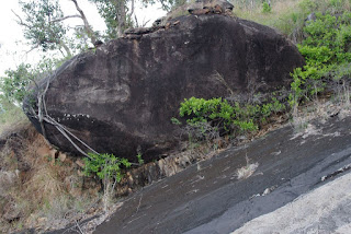
The mountains beside the Cook Highway formed when magma rose up into cracks that formed in the deep deposit of ocean sediments at a time when the east coast was under tension. The sediments were cooked into metamorphic rocks and the magma solidified to form granite. All granite forms at least two kilometres below the surface and is then uplifted, however usually the stone into which the granite intruded has long eroded away leaving only the granite geology. Along most of the Cook Highway, the granite is still in the process of losing its cover of metamorphic rock. Between the metamorphic rock and the granite is a contact zone which is a hard, almost mirror smooth surface probably composed of melted marine sediment. These surfaces are steeply sloping and are hundreds of metres long. There is no more perfect slip plane. At the top of the mountain is exposed granite, which weathers in the usual fashion and creates boulders. They mystery is how hundreds of thousands of tonnes of earth and boulders suddenly become mobile and I don't really know so I am going to speculate about what I think happens. The slope is approximately one in three, which from my carefully conducted experiments of rolling rocks down slopes, is the steepest slope where rolling rocks are more likely to come to rest than keep rolling. Usually they come to rest after after hitting an obstacle or a few inefficient end over end tumbles. Many boulders created by weathering of granite outcrop might roll down until the collide with trees or terrain and collect on the mid-slopes of the range which have metamorphic soils. Soil and small stones washed down from the kilometre long slopes above the exposed rock faces may also build up over time on the rock faces, creating landslide fuel for the future.
 |
| A big rock that almost kept rolling |
 |
| A wedge of soil on a slip plane. The slope in the foreground probably shed its load. |
In deducing the mechanism for these landslides, It would really help to know where the landslide originated, above the mid-slope granite exposures or below? Unfortunately, it does not appear that this information was recorded for the 1951 debris flow. Geosciences Australia (GA) in their report titled Quantitative Landslide Risk Assessment of Cairns (AGSO RECORD 1999/36) estimates that the landslides described in this post brought down between 180 000 and 720 000 tonnes of material and buried sections of highway to a depth of 3 m. GA consider that the rainfall event that triggered this landslide has a return interval of about 400 years, however that does not factor in climate change. The key issue may also be accumulation of material over a slip plane rather than rainfall and the rate of this process was not estimated in the report. I would think that the return interval for large landslides could be in the order of 100-200 years.
When the ground does let go, the one thing that is certain is that the debris flow hurtles down the gullies. Beside the small creek I followed, the debris flow averaged 30 m wide and formed an elevated inclined plain. It is likely that nearly all the trees present in the gully would have been ripped from the ground and carried away. Occasionally, when a few large trees formed a row across the gully, they were able stand against the debris flow. These trees by virtue of their being there to halt part of the debris flow provide indirect evidence that the flow occurred decades ago, not hundreds of years ago. In many places the sides of the gully were scoured back to bedrock. The evidence shown here is repeated in most of the creeks on this section of coastline. On some of the larger and most damaged creeks, the vegetation has not recovered. When the trees were destroyed, tall exotic grasses and lantana moved in to form a blanket of weeds that have suppressed the regeneration of forest.
 |
| The sloping surface of the old debris flow occupies the middle of the gully |
 |
| A few trees stood against the onslaught and built a wall of rocks |
 |
| The tree on the right has roots at two levels showing that it has seen 2 debris flows. |


I remember very well the huge landslide during January 1951 on the Port Douglas road. Searching to confirm the date met with no success until I stumbled across your web article. It is very comprehensive indeed, and is correct - within the limits of my ability there. From memory, the subsequently re-built road was, in places, stated to be constructed over the rubble and twenty feet higher than previously.
ReplyDeleteI also read your article on people and crocodiles at river estuaries. I have some familiarity with Crocodylus Johnstoni. Though I have little first-hand knowledge of salties (maybe fortunately), I am amazed that you are prepared to paddle around on something so flimsy while being fully aware of that particular environment. Here I should declare my own past.
During 1948 and 1949 I spear-fished the length of Freshwater creek from the then “Intake” rapids to its mouth with the Barron (though I bypassed one large pool on the flat below the Intake because I felt uncomfortable about it). I was thorough in fish finding, but saw no crocodiles. In that time while wholly in the water I came across [Macleay’s? water snake, long-finned eel, eel-tailed catfish, jungle perch, long-tom, bull-rout (a nasty hurt), etc..]. Freshwater Creek at that time had a very popular swimming hole immediately above the then creek crossing of the road to Redlynch.
The Barron also had a popular swimming hole immediately upstream of the then Kamerunga bridge – which was just upstream of tidal reach, and a haven for bull-routs underneath. Swimming took place in the upstream end of a largish pool, where water came in from rapids around an island. There I came across, at about 3m depth, two eels estimated at about ten pounds each. It is the only time I have seen this species, and I expect they were Anguilla obscura. Even more curiously, at slightly less depth and close to the run-in from the rapids, I was eyeballed by the ugliest fish I had seen to that time, and I estimated it at four feet long. I came up for air and to think about it, and went down had another look at it. Deciding, correctly, that it was a gigantic flathead and time to do something about it. Diving again, I found it had decided that it wasn’t going to look at me again. I only came across one barramundi there. Just upstream, at then Lake Placid, fishing was forbidden, fish-frenzy occurred for tourists at fish-feeding times, and people would swim in lake Placid both day and night.
I write this in contemplation of the changes which have or have probably occurred 73 years later. I note that whatever crocodiles were in Lake Placid then have been replaced by more feisty types, a young crock last year having grabbed a young lad around the head, but found that too much to handle.
Thanks for the information. We are loosing a lot of information with time. The information on eels is interesting and I will follow that up. Crocodiles certainly do live near the old Kamerunga Bridge. So do some other animals of note including bull sharks, freshwater moray eels and giant trevally.
ReplyDelete