Showing posts with label samphire. Show all posts

Thursday, 13 July 2017

Salt Pans of Wunjunga

Bowen famously has a salt mine at the entrance to the town. Tourist information used to impel people not to be put off by the ugliness of the salt flats and to continue through to the town. Yet in their own way hypersaline environments are beautiful and interesting. The only place I have found a publicly accessible salt pan which dries to a salt crust is at Wunjunga, which is just south of the Burdekin and on the Bruce Highway.  Driving into Wunjunga during the wet is like driving through a lake.

In the wet season, the salt pan is a shallow lake
Mosquito larvae are present in numbers so don't go there at night if you value your blood

A freshwater fish (spangled perch) swimming on its side in shallow water in an attempt to find freshwater
During the wet season when rains are heavy, the salt flats on the inland side of the salt pan complex drain slowly and become temporary freshwater wetlands.

Bird life is intense, so many birds and so many species
Some birds are timid but others will tolerate a careful approach
Closer to the coast tidal influence dominates and signs of freshwater influence are lost. Just before the beach is a shallow basin that is a saltwater lake during the wet season (shown above), and a bare salt pan with a small hypersaline lake in the dry. Large salt crystals form patterns in this lake.

The shallow lake almost completely dries

The bottom of the lake is encrusted with large cubic salt crystals

Delicate petals of salt spread over the surface
On the bare dry silty surface exposed by the drying lake there are unexpected signs of life. Every solid object is encrusted in barnacles, all dead as the lake fills seasonally and not with tidal cycles. A non-tidal saline lake with barnacles is not a common thing. The only other occurrence that I could find was the Salton Sea, a lake in California that is 70 m below sea level. The beach there is actually composed of barnacle shells. At Wunjunga, meat ants range across the bare flats and probably consume the dead barnacles, leaving empty shells.

Barnacles encrust every surface
A large green tiger beetle was running around in a completely bare expanse. Tiger beetles are predators and I assume they specialise in feeding on insects that land on the salt pans. When I tried to catch the beetle, it ran so erratically that it was almost impossible to catch. Tiger beetles can fly as well as wasps but their running skills are even better.


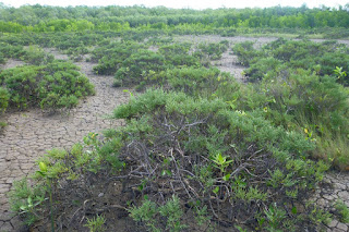
At the edges of the bare flats, succulent Tecticornia shrubs resemble staghorn coral. Their flowers are almost microscopic yellow specks that poke out between the stem segments. After colouring up, the stems shrivel, releasing segments that contain seed.

Tecticornia going purple

A diversity of succulents is present
Small banks of raised ground lie within salt pan and support an array of grasses and succulents. These areas are important to nesting birds and with their light silty soils are rather delicate places. Tread carefully in these places and look for animal tracks.  For such a harsh environment, there is plenty to find if you take the time.

Monday, 28 March 2016

Coastal Grasslands near the Tip of Australia

Behind the mangroves of the great inlets of Western Cape York Peninsula are vast grasslands that can be a few kilometres wide and many kilometres long.  This post shows a grassland at Port Musgrave and some images of Unigan nature reserve in Weipa.
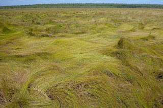
View across grassland toward paperbark woodlands on far side
Looking toward bauxite plateau over a sward of salt tolerant sedges (click to enlarge)
These grasslands, which are also known as marine plains, form an extended transition between sea and land.  Marine plains have an imperceptible slope, descending at 1 m per kilometre from landward edge to mangrove edge.  Within the plain, the vegetation gradually changes from seasonal freshwater wetland to saline marine flats.

Tea tree sapling in blady grass on a marine plain, Port Musgrave
View of wet blady grass flats near bauxite plateau with mangroves in distance
The grasslands are both spectacular and a challenge to the senses.  Their great uniformity offers no secrets and it is tempting to leave after a few minutes.  Yet this is a unique and productive ecosystem and if you can adjust your perception, there are things to be seen and environmental lessons to be learned.  People used to live in these areas, how did they survive?

The dangers of these areas that needs to be considered before setting out to experience them.  Savage feral cattle which were set free in this area over a century ago and without much parasite resistance, are crankier than modern cattle.  Feral pigs seek out the best patches of wetland and turn them into hectares of muddy slosh.  After walking through these areas I needed treatment for hook worms, which created thin itchy trails of blood beneath my skin.  The well-known threats of crocodiles and snakes are probably less of an issue here than elsewhere as they are not easily found even when searched for.  In the dry season fire is a serious risk.  When all of Cape York Peninsula is on fire, the air becomes thick with smoke and distant views are lost.  Fire is often out there but you don’t know exactly far away it is, so it pays to have firm ideas of how to escape in the event.  I have not seen a grassland burn, but I imagine it makes its own winds and would be a fierce unpredictable hazard.  Most grasslands are burnt annually.  Finally during the wet season, grass swamps can be heat traps where the air is still and humidity reaches 100%.  In the worst conditions, human endurance is about ten minutes.  Even dark still waters can become so hot that they are above the threshold of pain.  Warning over, lets continue.

Feral short horn bull, Port Musgrave
These things are more of a health hazard than crocs
Surrounding the inlet is a thin band of mangroves.  A single high tide every 24 hours (not two as is normal) would not provide enough flushing to keep dry season salinity down.  The neap tide-spring tide cycle would leave many areas to dry out for weeks on end.  It is very saline close to the inlet. The inner edge of the 100 m wide mangrove fringe has a strange thicket of club mangroves with swollen stems and salt encrusted leaves.  In a few places tall succulent shrubs are present, which resemble cactus with fine branches.

Mangrove fringe, Port Musgrave
Mangrove fringe around inlet showing zonation of species with increasing salinity.
Inner edge of mangrove fringe has a thicket of club mangroves (Aegialitis annulata

Chenopod shrubland on marine plain, Port Musgrave
Small areas have unusual shrublands with 1 m high succulents (Tecticornia indica)
A narrow saltpan separates the mangroves from the grasslands.  Soils in this area are swelling-cracking clays.  These black clay soils which are normally found in inland areas swell greatly when wet and conversely shrink and crack deeply when dry.  Few tree species can endure this type of ground movement.  Well below the the low ridge that marks the limit for regular spring tides, there is a strange grassland which must flood with seawater many times each year.
Xerochloa imberbis grassland, Port Musgrave
Xerochloa grassland fringed with Batis.  Mangroves in distance
Cracking soil of a marine plain on Cape York Peninsula
Large cracks let the soil dry out
Closeup of green Xerochloa imberbis stems
Xerochloa imberbis has tiny leaves and mainly uses stems for photosynthesis
Landward of the king tide ridge lies a broad sedge flat.  The heaving of the soil probably creates small round Gilgai wetlands in which Chinese water chestnuts (Eleocharis dulcis) grow.  Pigs seek dig up many of these wetlands and may have even created a simple agricultural system, where they deepen and improve the swamps that grow their food.  Humans can eat the tubers as well and they taste great, raw or cooked.
Chinese water chestnut in natural habitat
A large spring-fed drainage line with Eleocharis reeds and stunted mangroves.  
Despite heavy rains, drainage lines in the grassland are tiny or non-existent across most of the grassland.  Rain would have to drain across flat ground through decomposing vegetation and even dense beds of aquatic plants that spread below the grass.  Before the water could drain, more rain would have fallen keeping the area wet for months on end.  In the dry season, the flatness and impervious clay soil ensure that once the surface moisture is gone, drought will commence suddenly and be unrelenting.  This is an ecosystem that switches between being waterlogged and drought stricken.

In bauxite areas, freshwater seeps out of springs and into the grasslands from the base of the jump-up that separates marine plain from bushland.  Until the beginning of June, these areas have lush grasslands, with grass taller than a man.  Then in August/October, these areas burn.  The total loss of vegetation is hard for small wildlife to cope with and the area has many pigs and dingoes, both of which are major predators so there is very little wildlife even frogs.  Poor nutrient status of the soils probably also contributes to the scarcity as even cattle do not thrive here.

Panicum trachyrhachis grassland
Panicum trachyrachis wet grassland
Wet grassland, Cape York Peninsula
Floating Azolla fern, bladderworts and other species form an aquatic understorey 
Burned grass stems on marine plain
Stems of grassland burned before completely dry (~August)
In Unigan Nature Reserve, which is near Weipa, signs of the original aboriginal people who lived grassland-mangrove boundary remain.  They ate cockles in vast quantities and discarded the shells form huge heaps which rise above the grasslands like artificial islands.  Native fruit trees provide shade.  How they fished for cockles in the crocodile capital of Australia and how they survived nights with mosquitos that drill into bone, I think those secrets are lost.

Close up of cockle shells
Cockles were on the menu
Heritage-listed cockle shell mound near Weipa
One of the heritage-listed shell mounds that is in the middle of a grassland and close to the mangroves


Saturday, 4 October 2014

Swamp-oak Forest - Endangered but Hard to Love

Swamp-oak forest which occurs around Brisbane is an endangered vegetation type.  Despite being endangered, it was one of the most wildlife unfriendly vegetation types I had ever seen.  Even though swamp-oak forest straddles the highest high tide line, it has a fraction of the wildlife present in adjacent ecosystems.  Mangroves are full of life and the paperbark swamps and eucalypt forests have myriads of honeyeaters and even koalas.  Swamp-oak forest in contrast is so poor that a vast area of swamp-oak was planted around Brisbane Airport as it is so unattractive to birds, it would reduce bird strike at the airport.  Jet engines usually have to be rebuilt after they ingest birds, so bird strike can serious impact airline profitability.  Ansett Airlines threatened to quit Townsville due to this issue and I had to investigate the contribution that vegetation making in attracting birds to the airport.

Ibis eats McDonalds for breakfast in Brisbane CBD
In fact is was reported that the white ibis, which is the sworn enemy of the jet airplane, only became a nuisance after some were hand raised at a Gold Coast wildlife sanctuary and released into the wild.  These ibis were not afraid of people and became urban birds that raided rubbish tins and breed up into an unnatural population.  Unfortunately for Coolangatta Airport, the birds nested in a wetland not far away.  The bird strike issue was so dire, that people with long poles were hired to go into nearby forests and poke ibis nests to bits to force the birds to breed elsewhere.  Brisbane being not far from Coolangatta  for an ibis was reason enough for Brisbane Airport to plant swamp-oak on every patch of unused land to discourage the dreaded ibis and other better behaving wetland birds.  In my youth on the south side of Brisbane (~1980's), ibis were uncommon and were usually feeding on the banks of mangrove creeks and were never raiding rubbish.
An open forest of swamp-oak (Casuarina glauca)
Now that I have established that swamp-oak forest is a wildlife desert, I will ask you to reverse that position. It is not that the swamp-oak forest has improved, rather the surrounding land has become worse.  Bushland remnants in Brisbane are generally occupied by noisy miners, which are a vicious species of honeyeater that lives in large colonies.  Noisy miners harass small birds in to leaving or dying.  Magpies and butcherbirds help them in this nasty business. Brisbane bushland has also been overrun by invasive garden plants and barely resembles the native forest that once existed.  Now that the good environment has been overrun by baddies, the poor environments which are too poor for weeds and noisy miners have become important sanctuaries for the smaller birds.  Imagine what this means for the pre-development environmental assessment process.  Previously the poorer habitats would have been the automatic choice for development and arguments would be made for preserving the areas with the best remnant trees.  I will certainly be careful before making that sort of argument in the future.
A mistletoe bird eating mistletoe berries
This mistletoe is common in swamp-oak forest and has leaves that look like swamp-oak needles
Mistletoes with broad leaves are also found on swamp-oaks negating
the idea that mistletoe foliage resembles the foliage of its host tree
Mistletoes are a heavy burden for a tree
Besides being a place where you can still hear the voices of little birds, swamp-oak forest and saltwater couch grasslands are places of wide open space.  Only 8 km from the centre of the city (Storey Bridge) are the wetlands of Bulimba Creek, known as the Hemmant Recreation Reserve.   This area is about 1 km wide, 2 km long and between bridges, Bulimba Creek flows for 7.5 km through the wetlands.  Paradise it is not, but in a crowded city you take what you can get.  There is a canoe trail with racks and taps for washing canoes.  It is also possible to walk around but there are no formed trails.  If you need blue sky and open space, this could be your place.
Saltwater couch grassland bordered by mangroves and swamp-oak forest
Bulimba Creek
Saltwater couch grasslands are the home of the saltwater mozzie, so go prepared or go in winter when they are dormant.  And don't wear you good shoes. On very high tides, the saltwater couch grasslands are submerged.
Samphire plants grow in patches in the grass
Mangrove seedlings floating in a saline pool
Further Reading:

Thursday, 31 July 2014

Grassy Salt Pans of Cairns

Almost exactly 100 miles/160 km down the coast from the succulent covered salt pan near Cooktown is one of the few remaining salt pans near Cairns. Despite being so close that a lazy crocodile could drift from one to another in less than a week, the botany of these two salt pans is very different. At Cooktown, it was all succulents, near Cairns it is usually nearly all grass. In Google Earth the photo pattern of each vegetation type is remarkably similar. Surprises like this remind me that neither I nor anyone else I know of can fully understand why things grow where the do. Until we can understand why what grows where, environmental management is just educated guess work.  I think students and rangers could do mini science projects to find out why some places that should be similar are entirely different.  Professional scientists don't answer these questions as they need to maintain their fame and are not interested in easy research.

Sporobolus virginicus
Saltwater couch grassland/salt marsh at Yorkeys Knob
Most of the original salt pans and samphire flats around Cairns have been lots to development so I have to be careful about deciding that Cooktowns salt pans are different to those found near Cairns. Many salt pans within Cairns City were reclaimed. Cairns Airport is on what once was a salt pan and the major agricultural folly of East Trinity also included saltpans. Fortunatelly, we have a couple of good examples left and I think the remaining examples are similar to the ones lost. It is also unlikely that any halophytic (salt tolerant) species would be lost from the entire region. Salt pan plants are great colonists and show up even in salty ruts around the edges of sugarcane fields. For these reasons, I suspect that the succulent flats like those near Cooktown never occurred on salt pans near Cairns.

The natural park lands are quite pleasant provided you wear long clothes and don't dally around after sunset
Cooktown is in the Cape York Peninsula Bioregion and Cairns is in the Wet Tropics Bioregion. Bioregions are like countries for flora and fauna so this suggests that the salt pan vegetation could be different. Queensland has 13 bioregions. The bioregion boundaries were originally drawn by smart people with marker pens on paper maps. They were not something that came from a sophisticated analysis. Yet it is strange that even intertidal communities seem to have a sudden transition at the bioregion boundary. It is strange because most mangrove plants and animal species (fish, crabs, molluscs) occur from here to Africa and on almost every coastline in between. Given that most species are so widespread, why to comparable salt pans that are so close by natures standards have such different vegetation? I can only guess. Climate and geology and tidal inundation cycles are all quite similar. The founder effect may be at play. The founder effect is natures version of losers/keepers. The founder effect is when the first plant species to find a new island or in this case salt pan multiplies and occupies all the space making it very hard for new species to establish.  In very flat places, I have noticed that even a few centimetres in altitude makes a big difference to how long an area is flooded in inland areas or how many tides per month are experienced in coastal areas and I would start my investigations here. Succulents (Halosarcia sp.) do grow on slightly lower ground around the margins of the grassy swards in Cairns but are low and straggly.

Saltwater couch (Sporobolus virginicus) is the grass that covers the salt pan. We also have a second species of saltwater couch (Paspalum vaginatum) which often grows with the first species and looks very similar. The leaves of the first species are spirally arranged on the stems and the on the second only grow on opposite sides (called distichous).

Sporobolus virginicus has little tufts of leaves from underground runners.
Crabs and mud lobsters thrive in the saltwater couch and the ground is so full of hummock and hollows that I stumble through the grass rather than walking through it.  I wonder how the productivity of this marine grassland compares with mangrove ecosystems.  

Mud lobster mound peppered with crab holes
Shed exoskeletons were hanging in the grass
Ant plants also like the margins of salt pans and I suspect this is related to mists but I don't really know.  

Spiny ant plant
Myrmecodia beccarii - the spiny ant plant

Tuesday, 29 July 2014

Miniature Forests of the Salt

The salt pans and samphire flats of South East Queensland receive a lot of attention.  Yet the salt pans of Cape York Peninsula have a strange flora that is barely described on the internet or even in scientific reference sites such as the Atlas of Living Australia.  On a saltpan that is within  bike riding distance of Cooktown I found a veritable rainforest of succulents.  Within this miniature forest, the canopy was almost closed, the understorey was dark and humid and a thriving crab population.
Samphire flat with Batis argillicola near Cooktown
Batis argillicola mini tree
Being on a salt pan is to experience open space.  If you value open space and enjoy the visual intensity of colour and detail, being on a salt pan is like freedom to breath.  In this particular salt pan, it is also about being a giant that needs to tread carefully through a forest that reaches as high as our knees.

Tropical samphire flat
Should I even call this a salt pan?
Batis (Batis argillicola) is the main plant although approximately six succulents were present in total. Grass which is ususally present was not to be seen. Batis is quite large for a succulent and stands about half a metre tall.  The leaves are bright green and of similar shape and size to grains of rice and the seed pods are like green peas.  I am not sure how old the Batis are and I don't know if any one does but their stout trunk suggest they are old.  As there are no good photos on the net, here are a few more (yes it is true, stacks of stuff is still not on the net).

Batis argillicola shrubs near Cooktown
Batis argillicola is big enough to compete with young mangroves
Batis argillicola leaves and flowers
Leaves and flowers of Batis argillicola - the flower are tiny and only stamens are clearly visible
In the salty margins are some red and pink Halosarcia succulents, which come from the salt bush family.  The red is a protective pigment (a carotene) that allows plants to avoid damage caused by intense sun.  It is a sunscreen and a way of dissipating excess energy.  In such a dry landscape, plants cannot open their stomates to get CO2, so the energy captured by the photosynthetic pigments cannot be used and would generate free radicals that would corrode the plants cells if it the energy was not passed to pigments which reradiates the energy.  The pigments also have a sunscreen effect by blocking some of the incoming energy.  Back in the days of the ozone hole, it was predicted that many plants would go orange or red as they increase pigment levels to protect themselves as UV light also creates free radicals.  Breeding programs were established to put protective pigment genes into crops as many crops are badly damaged by intense UV.  The succulents on the salt pans also experience high UV from the sky and reflected UV from the salty surface.

Red succulents dominate very salty areas
Thinking of fauna, the crabs were in hiding and all I could find were mud whelks.  It seems that mud whelks thrive in a narrow band of ground around the margins of the saltpan.  Here shallow pools exposed to the sun provide better grazing than the surrounding mangrove forest.  However on this flat terrain, a mud whelk can easily move in the wrong direction and by after as little a five metres, it can find itself lost in the miniature forest with fatal consequences.
Mud whelk - telescopium
Hundreds of mud whelks clustered seeking shade under an isolated mangrove
Telescopium
There is a sad fate for those that crawl a few metres in the wrong direction