Showing posts with label beach. Show all posts

Friday, 28 August 2015

Seashell Coast - Pormpuraaw

One of the most remote towns in Australia is the Aboriginal Community of Pormpuraaw.  It is 210 km from the highway and approximately 500 km from the nearest town with more than 1000 people. The coast has a kind of desolate character that appeals to me.

Pormpuraaw foredune
Between the beach and the road is a grassland scattered with trees (Click photos to enlarge)
On arrival, I bought a pie and went down to be beach to eat it.  When I looked up, I found that I was being watched by no fewer than three medium to large crocodiles.  They were not sneaking up on me, rather I had just arrived where they sun on the beach near the river mouth.  Pormpuraaw has crocodiles up to five metres long and it is one place you do not want to take risks.

Estuarine crocodile
One of the crocodiles that was watching me
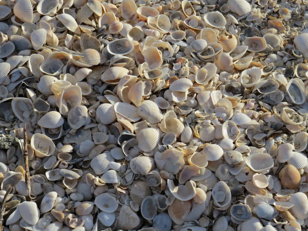
Pormpuraaw town is built on a couple of beach ridges made of sand and seashells and is wedged between an enormous salt pan and the sea.   Near the town is desert-like beach 8 km long and in many places the face of the beach is almost entirely seashells.  The shells are large and perfectly formed and it feels like a crime to walk on them.
Shells on Pormpuraaw Beach
The beach is at least half seashell, and the drifts are all shell
Close up of the seashell drift that runs across the middle of the photo above.
The sea is usually flat as Pormpuraaw is on the west coast of Cape York Peninsula and the prevailing trade winds blow offshore.  Pormpuraaw is in the Gulf of Carpentaria and this area has only one tide a day and has a reduced tidal range.  Actually, I am not totally sure, there are some places on the Australian coastline that do not have tide gauges and are hundreds of kilometres from a place that does.  The Gulf is also a bit strange.  Gove, which is one side of the Gulf has two almost equal tides each day and Port Musgrave, which is directly opposite has only a single tide each day.

Beach with a washed up sea fan in the foreground
Near Pormpuraaw, at low tide sand flats are exposed but they are flat and have neither the level of wildlife or the interesting patterns that I find elsewhere.   What is present are dead shells from two of the worlds largest molluscs, the bailer shell and the Australian Trumpet.  The shell of the largest Australian Trumpet ever found was about 91 cm long is actually the largest living shelled-gastropod.  However most of the trumpet shells at Pormpuraaw are about 20 cm long and few are in perfect condition.  Bailer shells were used for bailing boats, hence their name.  Broken shells of both species are common.

A small bailer shell
At either end of the Beach is a river and there are some huge crocodiles in these rivers.  I did not have a boat and took my photos just from the riverbank.  Mind you, I have a superzoom camera.  Would you believe that there were deep human footprints in the very soft mud along the waterline of the riverbank directly opposite where I photographed this crocodile!

Middle reaches of Chapman River, Pormpuraaw
Chapman River about 2 km from Pormpuraaw town
Sunbaking saltwater crocodile
5 metre crocodile on opposing river bank
If you go to Pormpuraaw, be sure to ring the Council first and make sure that their camping ground or guest house is open.   Allow about 3 days and be prepared to do something slow.  It has spectacular bird life, photogenic scenery and the locals are great.

Salt pan near road to Pormpuraaw

More about tides: I actually wanted to put in a tide gauge and be the first person to understand the local tide. Tides are the result of resonances between celestial bodies and the geometry of tidal basins and there are a large number of possible resonances.  I was surprised to find out that tides do not really flow in and out according the nice sinusoidal curve shown in tide charts.  There can be as many as six tides a day and an incoming or outgoing tide can reverse direction for a few minutes before resuming its original direction.  The observed tide is the result of several slow motion waves added together and these waves all move to different rules.  

To measure the tides, all that is needed is a self contained pressure gauge with integrated data logger.  Anchor it to the seabed in a sheltered location and collect at least two weeks of data.  Computer programs can then analyse the data and  make a tide chart.  I would probably like to collect more data as seiches may also occur in a place like the Gulf where the sea is shallow and strong winds blow.  This stuff actually matters.  In some harbours in Queensland, the amount of coal or ore that can be loaded into a ship is calculated according to what the tides are doing so as to maintain exactly 1 m clearance under the hull as the ship passes over the shallowest point. 

Saturday, 25 July 2015

Barron River Sunset

At the very same time that I was staring at sand for the tiniest insects that the human eye can see, there was another person on the sand flats photographing the scenery with the best camera I have probably ever seen. The camera was a 36 mega-pixel Nikon D800 full frame DSLR using prime (fixed length) lens. Prepare to see the Barron River sand flats as you have never seen them before. Click to view.

Machans Beach, Barron River Mouth


Machans Beach Sunset

The photos show what we would see if we could look into the sun. I talked to Tony as he waited for the clouds to fire up.  There are a few minutes each day when the clouds are lit from below with the red sunlight of the setting sun.  Trying to be of value, rather an annoying person, I mentioned that the pelicans come in fast and low at about this time of day as they head to their night time retreat.  Tony took up the challenge.  It was about half an hour after the sun had set before the first pelicans showed up in silhouette against a sky orange with volcanic dust.

As the pelicans have to fly into the trade winds, they tend approach the river in the wind shadow of tall trees then suddenly drop down to a metre above the ground to fly under the wind.  Their flight path is almost predictable so we could let them come to us.  A disappointingly low number of pelicans had gone past and the sky was now so dark that even black and white pelicans were hard to seen.  But at that moment Tony spotted some pelicans flying further out and keen to show what a top end professional camera can to took some photos of the distant flock passing in the blue-black of early night.  The results are below and show something quite amazing, the flock of pelicans was being lead by a Black Swan!

Pelicans flying above sea


Pelicans being lead by a black swan


There are a lot more photos of our tropical coast on Tony's web site.
Photo I took of Tony when he was photographing the sunset.


Tuesday, 14 July 2015

Miniature Insects of Tidal Sand Flats

Sometimes if you just look hard enough you may see something no one else has seen.  Unable to find the time to go somewhere new, I decided to sit on the edge of a sandbar and watch at the seawater gradually draining from the sand and I kept up my concentration until I saw something that I had never seen before.  Tiny flecks of life appeared to be moving around on, under and above the water surface above black patches of mangrove debris.  Moving above the surface implies insects and insects the size of dust particles can fly through water as well as air! However it was hard to believe that such infinitesimally small creatures could survive in an environment that lasts only a few hours before the tide comes in violently reworks the very ground.  I can remember ten men trying to open a metre wide channel from a nearby blocked creek to the sea.  Such is the rate at which the sand is moved around that digging like mad they could not open the channel faster than the sea could fill it back in. Yet it is in this ocean of highly mobile sand that the flecks of life are present.
The sand flats can look like this one day (click to view)
I described these insects to the entomologists at the local university to a muted response.  It was uncomfortable to call what I had seen a community or ecology as how can a community exist when the very terrain is destroyed and recreated every few hours.  Worse still, finding the flecks of life a second time eluded me.  Even scraping up the mangrove debris and going through it under a microscope failed to yield anything other than a few larval crabs.  For nearly two years I have been looking. If I put a bright LED torch on the sand at night, flecks could be seen jumping through the beam.  However the nights are seldom still and it was difficult to be sure that the flecks were not flakes of matter propelled by the breeze.
Hours later the sand flats can be a very different place, in this case turned over by stingrays
A few days ago, I tried the old trick of just looking until I saw something, this time in a different place and I rediscovered this lost community.  Perhaps this community is only present in the winter (June-July) or perhaps it is only present in certain areas.  I am yet to work this out.  It was late in the day and the sun was so low that the shallows had become dark yet anything on the water surface was still illuminated and suddenly the true number of these little creatures was revealed. To see the creatures, you must approach the waters edge with great care as the weight of a foot fall even a half a metre away gently shifts the sand, causing the sand to slump just slightly and warning the little creatures to depart the area.  Video confirms that they are moving around the edges of the water, as I cannot easily see them with the naked eye.  I can only see them on the surface of the water and here they are caught by the wind and streak across the surface so quickly that in a few video frames they are gone.  Falling into the water does not seem to bother them and may in fact be part of their normal habitat.

A rill between sand ripples at the mouth of the Barron River
Springtails floating on the water seen in silhouette
I filled a small bottle with surface water and took it home for a look under the microscope.  Even under a microscope at 40 x the creatures are small.  They proved to be springtails, small wingless insects that can fly by flicking themselves into the air with a spring-like rod that folds under their body.  To the naked eye they look white or brown (could be a few species) but the brown ones are actually bright yellow.  The captive creatures were placed on a drop of water on a black surface and I photographed then with my compact camera held over the eye piece of the microscope.  The first photo shows the springtail beside a fine blonde human hair.  The other photos show the springtails rolling around on the surface of a drop of water.  Under the abdomen in the last photo is the spring that gives springtails there name.


Springtail beside a human hair


Are the springtails just a curiosity or are they important?  Their sheer numbers probably make them important and potentially they are food to the many juvenile fish that live in the pools.  Aside from that, I wonder if their yellow colour is a sunscreen.  I also wonder if they are part of a detrital community based on bacteria that live on buried organic matter as they seem to be present mainly in shallow areas where detritis is present in the sand.


Wednesday, 5 November 2014

Constructing Machans Beach Seawall

Machans Beach which is a sandy island in the mangrove-infested Barron River delta is getting major seawall upgrade.  Category 5 cyclones have become regular events during the previous decade with at least 5 nearly landing at Machans (Ingrid, Larry, Monica, Yasi and Ita).  When you live here you can remember them well as you have pack up your bags each time and flee.  Machans Beach was lucky and was not directly hit but a place that is very similar in almost all respects was hit-Tully Heads.

The old seawall is very steep and many of the rocks are not supported from below
Graphic of seawall design from public notice sign -showing the lower angle and extended toe.
Like Machans Beach, Tully Heads did not have a properly engineered seawall.  The seawalls were constructed over time in response to local erosion events or storm damage.  Clearly these sorts of seawalls do not stand up to category 5 cyclones and at Tully Heads, nearly all the homes in the first 2 rows were lost. Seawalls can also be dangerous and kids playing on seawalls are sometimes killed by shifting stones and there have been local incidents.  Upgrading the Machans Beach seawall became a priority project.
Gap bashed though seawall by Cyclone Yasi - Tully Heads

Rocks thrown up from seawall onto lawns
To begin at the beginning, Machans Beach needs a seawall because the beach eroded.  The beach eroded because someone cleared the vegetation between the headwaters of two creeks and during a flood, one of the creeks, Thomatis Creek flowed backwards from the Barron River, over land and into the headwaters of the Richters Creek.   As a result of that flood in 1922 was that a channel was scoured between the two creeks and the Barron River developed a new path to the sea that was 7 km shorter than the old channel.  Much of the sand carried by the river followed the new path to the sea and Machans Beach lost much of its sand supply.  Adding to the issue, the old mouth of the Barron also shifted and the sand that was coming out was channeled out into deeper water.  Sand miners were also dredging very large amounts of sand out of the river channel.  It is an open question whether the mulit-million dollar seawall now under construction would have been needed if some controls had been placed on inappropriate land clearing 100 years ago and sand extraction from the bed of the Barron River was banned earlier.  A full description of the root causes of the beach erosion issue was written up in a Mulgrave Shire Council report, dated 1986.

Machans Beach Esplanade is very narrow, so another way had to be found to access the seawall
Construction of the seawall began at the northern end near Barr Creek at the beginning of May 2014.  A causeway was constructed about 15 m out from the existing seawall.  This method of construction avoided having to use the narrow esplanade and having to remove all the trees that were perched at the top of the old seawall. Seventy tonne trucks would reverse down the causeway and dump stone to the side of the wall so that a large excavator (30 tonne?) could individually pick them up and place them at the end of the causeway to extend the causeway. The size of the largest rock approaches the size of some of the smallest cars and it surprising that the excavator could handle them so easily.

Tipping out rocks
A larger rock barely fits in the bucket
Reversing along the wall to the excavator
Mirrors are handy for this job
By November 2014 the seawall stretched more than half way along the Esplanade and the causeway was in excess of 1 km long.  Trucks would drive forwards along the causeway and turn on little ramps that ran from the causeway to the Esplanade.  These ramps are also where the excavator is parked when the tide is high.  The trucks then reverse the final hundred metres or so the the waiting excavator.

The causeway is now so long, that the excavator has to wait for loads of stone to arrive
Before placing rock, mud is dredged from the tip of the causeway and placed on the side
A bucket full of mud - the mud was plastic so not much turbidity resulted
Dumping large rock with the excavator poised to catch the truck should it start to roll over
View along the top of the partially finished new seawall, showing soil being laid where the footpath will be
The seawall is made up in layers, which small stone (~150 mm) being formed into bank, which is then covered with a layer of geotextile.  Geotextile will add strength to the seawall as it has a very high tensile strength but its main purpose may be to stop fine material being eroded out of earth behind the wall by the movement of tides and waves.  Loss of fine material can create deep holes in the ground.  On top of the white geotextile is a layer of smaller rock, each of the smaller stones would be the size of the bucket on a builders wheelbarrow, which is roughly the size of the stone in parts of the original seawall.  On top of the smaller stone, truly large stones are being places with may having a long dimension of close to 3 metres.

Layered construction of seawall
The project will continue well into 2015 and I will keep you posted.

Monday, 4 August 2014

Life in a Beach

Each area of coastline is different.  It is not a case of the same species be present is slightly different numbers, each place seems to be the product of different ecological rules.  Sandy beaches are normally somewhere where animals are very scarce, perhaps only a few ghost crabs are present.  However the beach at Archer Point, close to Cooktown, is literally crawling with life.

Amphipod burrows
Amphipod burrows near high tide line


Amphipod about 1 cm long.
An amphipod


I have never seen a beach covered with burrows all the way from the low tide mark to the high tide mark before.  I even had to dig up the ground to find out who was in the burrows.  Amphipods jumped out of the first handful of sand so must be just below the surface.

Amphipods are basically a small (1 cm long) prawn-like animal that walks on land.  They have very big eyes and are nocturnal.  When chased, they can jump like crazy to avoid being caught.

Since seeing the amphipods at Archer Point, I have kept my eyes open and have scanned several beaches which seem similar in terms of protection and sand properties.  Finding amphipods on these other beaches is a struggle.  Normally, there are a few amphipods under washed up leaf litter and seaweed.  It is unusual to find large numbers on a beach that is almost clear of plant debris.  I suspect that there is freshwater seepage concealed within the beach which some how helps the amphipods.

Recently 4WD vehicles were allowed back on many Queensland beaches.  Scientific research had shown that vehicles driving on the beach crush many of the animals that live in the sand and hurt the ecology of the beach. My position on this matter is that each place has to be assessed individually.  It is nice to be able to pull up right beside the sea and relax and I would not like to see every beach fenced off.  Many beaches are reworked so much by wind and waves that few living animals are present and driving on these beaches does little damage.  However it is repulsive to find tyre tracks all over remote beaches where people should be able to enjoy freedom from such things.  In this case, there is no reason to drive on the beach at Archer Point as the beach is only 300 m long and has an unusual ecology featuring vast number of amphipods which would suffer due to vehicles on the beach.

There is no point in driving onto this beach as it is so short, yet lots of people do it
Amphipod holes beside tyre tracks