Monday, 8 August 2016

Oyster Reefs of Far North Queensland

In ecology an oyster reef is the classic example of an open ecosystem.  In open ecosystems nutrients pass through the ecosystem whereas in a closed ecosystem, nutrients are mostly recycled.  There are no truly closed ecosystems that we know of; however some of rainforests would come close.  Larger coral reefs also have a high degree of nutrient recycling so are functionally close to being a closed ecosystem.  Oyster reefs are open ecosystem because the oysters feed on plankton imported by water flowing over the reef and the oysters export frass and sometimes oyster eggs/sperm into the flow.  Nutrients come and go and only negligible amounts are recycled.  Given their conceptual importance, I was surprised that so little attention has been given to oyster reefs.
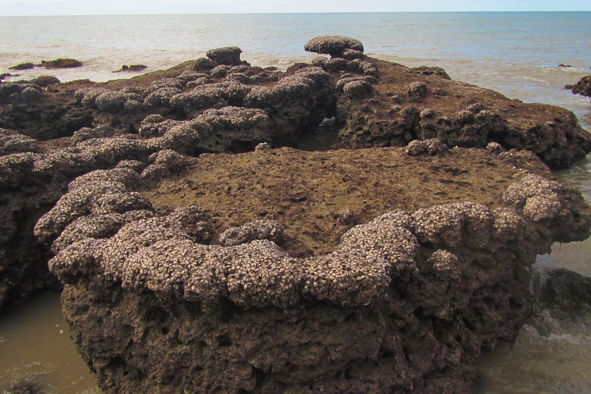
Mushroom-shaped oyster reefs on bed rock outcrops at White Cliffs, Captain Cook Highway
I noticed that oyster reefs were a distinct ecosystem on tropical Queensland shores about one year ago.  Wikipedia defines an oyster reef as a dense aggregation of oysters that forms a large colonial community.  Oyster reefs have their own ecology and can exist independently of mangroves, coral reefs and other tropical ecosystems.   As oyster reefs are small, ranging from less than a metre across to patchy reefs a few tens of metres across at the most, they are easy to overlook.

Band of oysters on landslide boulders at East Trinity boat ramp (click to enlarge)
Given that oyster reefs are nature’s equivalent to patches broken glass, it also took me a while to want to investigate them.  Oyster shells can easily cut into human skin.  Small pieces of shell often remain embedded in puncture wounds and cause serious infections.  Wading barefoot across a mud flat studded with oyster covered rocks is a testing experience as even the mud between the colonies is full of sharp buried shells.  A common way to have this dreadful experience is to pull up to a beautiful beach with a wide shallow reef flat that forces you to get out of the boat and walk ashore.  Some beaches have oyster covered stones, known as oyster beds, on the reef flat and these are the ones to be careful of.

Stony sand flats such as this one at Giangurra often have oyster beds 
Juvenile oysters cover many of the stones and these have cylindrical spines
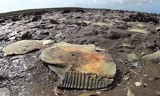
One of the worst places I have ever been was a saddle oyster reef at the mouth of Saltwater Creek near Cairns Airport.  Saddle oysters (Isognomon ephippium) are about 12 cm across with thin almost circular shells that when closely stacked look like a bed of axe heads.  Silvery dead shells littered the ground around the reef my first impression of them was of miniature compressed humanoid skulls.  The circular part of shell is offset to one side like the braincase of a skull in cross section and the hinge has a series of deep grooves that resemble tooth sockets.  The saddle oyster reefs stretched right across the bed of a creek that was only millimetres deep a low tide.  I was trapped between a series of these barriers and could not paddle my surf ski out or walk out as the soft mud was as deep as my legs were long and stretched for hundreds of metres.  It was the most vulnerable to crocodile attack I have ever been.  Having no easy exit, I decided to investigate the reef properly so that I would never have to come back, before committing to a two hour slog across the mud flats that involved sitting on the tip of the ski and kicking with both feet to move just 30 cm. 

Saddle oysters reefs consist of tightly packed vertical shells
The surrounding area is covered with their dead shells
Isognomon ephippium
The shells look like weird skulls
A milky oyster reef near Pretty Beach on the Captain Cook Highway lacks the danger but was also a bit depressing.  It is located on the crest of an uplifted coral reef that has very little living coral or other life. The oysters are only present in narrow bands around the margins of the coral platforms.  Oysters normally form a horizontal band on rocky shores that is close to high tide level.  As the entire top of the old coral reef is at oyster level, yet only some places have colonies of contiguous oysters, some other environmental factors must also be important.  I wonder if oyster colonies form much like snowflakes form with edges of the colony that are subject to the most current recruiting the most spat.  Curiously, there is little fouling of living milky oyster reefs by other organisms such as algae and barnacles.
Uplifted coral reef near Pretty Beach, Captain Cook Highway
Looking along the uplifted fringing reef
Not all reefs are ugly and some oyster reefs are pretty enough to be photogenic, particularly the shelves of oysters that form on rocky headlands or on huge boulders that landslides have delivered into the sea.  Unsupported shelves of oysters can extend out for over a metre.  Rough seas probably break off shelves that have grown too wide.  The oysters in the shelves are arranged like a malformed honeycomb into tall roughly shaped polygonal columns.  Most of the column is solid shell and is formed from layer upon layer of shell secreted underneath the living oyster.  Some of the solid columns are more than 10 cm long.  Unfortunately the columns are weakly banded and it is hard to count seasonal ‘growth rings’. 

Massive shelf of oysters near Thala Beach Lodge (White Cliffs)
Same shelf from other direction showing gap where part of reef has broken away
Small oyster reefs in lee of Taylor Point, Cairns
The ultimate oyster reefs in my opinion are the small unattached oyster reefs that lie on sand and mud flats.  These reefs are self-regenerating in that the only place new oysters can settle is on old oysters.  Self-sustaining unattached oyster colonies are not common with only few seen for each kilometre of coastline and they always occur on the landward margins of wide sand or mud flats.  I have also heard that aborigines once returned old shells to the sea so that new oysters could grow and it would be amazing if this was the origin of the unattached oyster reefs that I have observed.

Unattached oyster reef at mouth of Johnstone River, these oysters tend to get eaten by people.
Unattached oyster reefs with milky oysters develop on dead saddle oyster shells
An oyster colony in a midden at Weipa, shellfish were the major food source for local aborigines
All of the oyster reefs prefer relatively semi-sheltered waters or on exposed coasts, positions where waves are broken before impact.  They also prefer large rocks that stand in deeper water and which are probably less prone to sand blasting during rough weather.  It is thought that the lower limit of oyster growth is related to predation.  On floating walkways in marinas, oysters only grow near the water surface and are heavily predated.  Oysters often do much better on the piles within the marina oysters as piles are exposed when the tide recedes. 

Oyster reefs do not like places with high energy wave impacts
When trying to work out why oyster reefs form where they do, it occurred to me that oyster reefs might also be a real world example of DaisyWorld, which is the mother of all ecological theories.  Oyster reefs are mostly bright white yet they live on black rocks.  During summer, the rocks can get super-hot and suffering limpets stand up on their feet like mushrooms to get some air under their shells.  However oysters breathe water and must remain tightly closed and like daisies, they cannot move so heat must be a critical issue.  In Daisy World, white daisies cool the world by reflecting sunlight so could oyster reefs work this way too.  The next step is to look for scientific papers as surely this topic has been researched.  If not, doing some data collection on temperature differences between bare stone and oyster colony would not be too hard.

Oysters seem to do much better in colonies than they do as scattered individuals
One of the few rocks with scattered oysters, showing lots of dead oysters
In other countries and other parts of Australia, the habitat and ecosystem services provided by oyster reefs are highly regarded.  In north Queensland, the rich variety of habitats means that the contribution of oyster reefs to local species diversity is quite low.  However, there are organisations springing up to restore and recreate oyster reefs that have been destroyed over the years, including the Shellfish Reef Restoration Network.  In early Australia many oyster reefs destroyed for various reasons.  Some were mined and the oysters burnt to create lime for concrete.  In many places there has been a major loss of oyster reefs.  

NSW Oyster Fisheries 1883, Source: State Library of Victoria
Oyster reefs provide a complex three dimensional space where creatures could live, however the position of oysters at the top of the tidal range probably limits the number of species that could make use of that potential habitat in north Queensland.  I did not observe much biota making use of the habitat provided by oyster reefs I have examined.  Crabs including stone crabs and half crabs sometimes shelter under unattached oyster reef on tidal flats and algal turf sometimes occurs on old dead shells. 

Well developed oyster reef often has fissures and holes
This older reef has algae turf on the matrix of old dead shell
Large shelfs can collapse, creating oyster boulders that provide habitat for other creatures 
Oyster shells collected from beach that probably come from broken down reefs
1.  Due to crowding the oyster lives in an ice cream cone shaped space inside the column of shell
2.  Column seen from bottom, showing robust outer wall and layers of shell sealing
of the unwanted space below the living oyster
3.  Most columns have a stripe on one side and I assume this is the attachment surface
4.  This column (oyster shell) is 9 cm long, but columns can get a fair bit longer
Oyster drills are the most common visible natural predator of oysters.  In NSW oyster beds that once extended from the high tide line to the bottom of the coastal harbours but sub-tidal colonies were wiped out by introduced mudworms.  Humans are probably the main predator of the remaining oyster beds and reefs in the upper intertidal zone.  Indigenous people and to a lesser extent other people scour most of the coastline near Cairns looking for oysters which they mostly consume on the spot.  In accessible sections of coast, oyster populations are often depressed by over harvesting.  However given the notoriously poor diet of indigenous people, fresh oysters are probably a very important dietary supplement. 

An Oyster Drill - Morula marginalba


Tuesday, 26 July 2016

What Beach Vegetation was like 30 Years Ago

Back in the mid-1980’s when I first visited the beaches of the Barron River Delta near Cairns in tropical Australia, they had coastal vegetation consisting of open woodland with scattered large old trees, small thickets of saplings and wide open grassy areas.  As the beach was rapidly retreating due to sand mining in the Barron River, the face of the beach was completely covered in fallen woodland trees.  Today beach almond and casuarina trees dominate the foredune and these were planted by revegetation groups in the mid-1990’s.  What was once open and sunny is now heavily shaded forest with an understorey of mainly Singapore daisy.  Coconut palms, which were entirely absent along the uninhabited stretches of beach,  have been planted all over the place by people who think that all beaches need them.

Holloways Beach as it is in 2016 - a vista of Casuarinas and coconut palms
Much of the strand forest is beach almond, which create shady forests
Usually a blanket of Singapore Daisy covers the forest floor
There are some vestiges of old style coastline near Cardwell and along the coastline near Yarrabah, to the east of Cairns and these provide the photos in this post.  Small vestiges also occur on Taylor Point and inaccessible areas of the Cook Highway coastline on the way to Port Douglas.

Holloways and Machans had scattered trees in tall grass (this is Edmund Kennedy NP)
Tall paperbarks occurred in the swales between dunes and made up many of the fallen trees when the beach retreated
Dry rainforest trees occurred in pockets on the edges of the dunes.
Savanna was present on the sandy flats bordering mangroves (Redden Island)
I suspect that I arrived at a particular time when indigenous burning had been suppressed and the vegetation was in the process of change.  Without fire or attempts to graze the land, the vegetation rapidly thickened.  Vegetation thickening is when too many tree saplings become established and they fill up all the space between the larger trees forming what looks a bit like dry rainforest. 

Before thickening the forest had large trees with an understorey of shrubs and blady grass
After thickening, spindly saplings form most of the forest and the understorey plants are virtually eliminated
Since 1994, non-eucalypt bushland trees have replaced the previously grassy understorey and the tall trees have since died
To someone who has seen the bush before thickening, today’s thickened bushland is painful to look at.  When I first saw the north Queensland woodlands they were full of well-formed trees and shrubs that were very healthy and which had attractive dense foliage.  I now suspect this was the first generation of trees growing up in the reduced fire regime and was transitional to the thickened forest that we see today.  Younger people probably think that the forest remnants they see are representative of what once existed, however this is not the case.

South of Yarrabah had seaside eucalypt woodlands in 2016
The tip of Taylor Point has a tall and thriving sward of giant spear grass
For wildlife, I think that the beach vegetation of eucalypt/paperbark woodland with pockets of dry rainforest was more productive for animals other than black cockatoos which eat beach almonds.  In thickened vegetation the bulk of the saplings struggle to survive and barely fruit or flower.  In contrast the understorey shrubs in the grassy woodlands have more space and can thrive and produce much more food for animals.  Finches and wrens love the grass.  On the beach with the blady grass, every metre of beach had wildlife footprints, including water rat, bandicoots, wallabies, goannas, and even crocodile.  It is amazing how much wildlife these area can support in there natural state.

Wallaby and joey footprints on the beach


Sunday, 17 July 2016

Karumba - Queensland's Gulf Coast

Last week, I described the coastline near Innisfail which lies at the heart of the wet tropics on the east coast and in this post I will visit Karumba which is at exactly the same latitude and 580 km to the west in the Gulf of Carpentaria. Latitude is possibly the main driver of biodiversity around the world so comparisons of places that are at the same latitude are informative.  

My time in Karumba was limited and I can only offer first impressions.  The bushland near the coast has trees in a variety of faded hues giving the landscape a pallid appearance that suggests it is lingering rather than alive.  The town itself is bustling mainly with tourists but has an industrial character that comes with being a port which has a fishing fleet and mineral export facilities in a part of the world where few people would choose to live.  However for tourists, the town is an oasis and I went to the tavern for some of the best seafood available to await the legendary green flash which reported to occur when the setting sun kisses the horizon goodbye. 

A road train arrives at the depot in the industrial part of the town
Waiting for the green flash
The moment of truth, sadly it was not a green flash day
Behind the town’s airport was a beach with slabs of beach rock and armies of hermit crabs and further along, a mangrove swamp full of locusts.  The edge of the sea was clear and sandy bottomed and I could only find a few dull grey sea anemones clinging to submerged rocks although aerial imagery suggest seagrass meadows further out.  Near the airport the foreshore has clearly been exploited in years past, probably by mining of beach rock and shell grit which would have been used for construction.  The foredune has developed a sparse scrub of unwanted toxic garden plants that are now considered environmental pests.

All the plants in this view are exotic pests
Hawks, kites and every other kind of raptor are abundant and circling or settled on the low vegetation or the ground.  Kangaroos and wallabies hit by cars probably feed many of the birds however the vast numbers of grasshoppers probably form part of their staple diet as well.  Locusts in mangroves are not unheard of.  Usually they are found in Avicennia mangroves and are large, fast and clever enough to evade my best efforts at catching them.  I have to resort to grabbing them in the fading half-light on the cusp of night when I can see them just that little bit better than they see me.  I used to sell them to researchers who study insect flight.   Yet here in Karumba were so many locusts that birds of prey were ignoring them. 

A kite eating a roo that was pulled out of a bull bar at a truck stop
A locust on a mangrove
The coastal mangroves consisted only of a single species, Avicennia marina.    Nearly all of them were standing on a small arch of stilt roots, a feature not usually associated with this species.  The pneumatophores or pencil roots coming up from the surface were unusually long and thin.  Most of them supported dense colonies of tiny oysters.  I failed to find any fiddler crabs or other wildlife of note.  That suggests that this type of fauna is not abundant but one has to observe a favourable tidal cycle before making such a statement.  Mangrove fauna does not come out when the tides fail to replenish the fertility of the forest floor. 

The swamp had no defined edge with scattered individual trees taking on the sea
Tiny oysters completely covered many of the mangrove breathing roots
Tall and very dense breathing roots
Most of the mangroves had stilt roots at their base
Closer to town, the beach carries a heavy armour of beach rock. Tidal range seems to be comparable to the east coast with a range of approximately 3 m and the stone beach is both high and wide.  Deep fissures separate the stone into tessellating slabs.  A shell grit beach lies in the curve of the bay, possibly were beach rock has been removed and every square inch of this beach has been trampled by terrestrial hermit crabs.  During the day they hide under the slabs of beach rock, in the moist sand. 

Slabs of beach rock
The dimples in the beach are from hermit crab feet
Hermit crabs hiding in a fissure in the beach rock
A large hermit crab, Coenbita variabilis
Karumba no doubt has more to see than I could manage in half a day and I am keen to go back.  In this flattest of landscapes, tidal influence extends at least 40 km inland creating a mosaic of woodlands, grasslands, freshwater wetlands and marine plains.  In stark contrast to similar habitats on Cape York Peninsula, wildlife is abundant.  Time to get off the main road is essential and access to boat to investigate the Norman River or clear shallows of the Gulf would open a range of potentially fascinating places.

Marine plain with river mangroves, 40 km inland

Unfortunately, the only conclusion that I can reach regarding a comparison of the Innisfail coast and Karumba is that possibly rivers are very important in both locations as both beaches were at the mouths of massive river systems and would experience freshwater plumes.  The Gulf can also be more saline than the ocean average, particularly when tides recede from the extensive salt pans, and this would stress mangroves and select for types that can stand high salinities.  In large parts of the Gulf there is almost a total absence of stone so there is very little habitat for animals that need surfaces to attach to or hide under.  If there was one question I would like to work on it would be why were the mangrove ecosystems near Karumba so different from the mangroves of dry places on the east coast such as near Townsville or Princess Charlotte Bay?  

Sunday, 10 July 2016

Where the Sea is not Salty Enough - Mouth of the Johnstone River

When it comes to mangroves, the less salty the environment, the taller and more diverse are the mangrove forests.  The most magnificent of all mangroves are found in the tidal reaches of large freshwater rivers.  Unfortunately the same cannot be said for fauna as diversity drops off quite dramatically as soon as the salinity drops.  In fact with fish, only about 2% of fish species can survive in brackish zone and I am sure that even fewer invertebrates would thrive in this environment.   However to my surprise this effect can even affect biodiversity levels in the sea near the mouths of large rivers.

Aerial view of sand flats in 2013, with river mouth at top of photo
For many years I had been itching to investigate the wide sand flats on the southern side of the Johnstone River mouth in Far North Queensland (Australia).  The Johnstone River flows from the wettest part of Australia, a place which has 4 m per year of rain on the coastal plain and up to 8 m per year in the mountainous headwaters of the river.  Furthermore, the river does not have a large mangrove estuary and pretty much flows straight into the sea.  At the mouth is a sand flat approximately 1.5 km long and 0.5 km wide.  Inspecting the sand flats with GoogleEarth shows several parallel sandbars with darker troughs between.  At Yule Point, the darker areas were fossil coral reef and in the mouth of theBarron River, the darker areas were shallow pools that often contained something whether seasnakes or sponges. 


Large, soft sand ripples and shallow pools
Getting to the sand flats is tidally restricted as one has to cross a small mangrove creek to get there. A few things stand out immediately.  There is grass on the lower creek banks between the mangroves and the channel, an arrangement that I have never seen before and something that is no doubt only possible were the tides pump mainly freshwater.  On the face of the beach is a broad swath of black mineral sand.  Heading out onto the sand flats, the surface had oversize sand ripples which were strangely soft underfoot.  The much hoped for intertidal biodiversity was absent and the sand flats were almost sterile save for saltwater yabby burrows.

Black mineral sand on the beach
Eventually some hundreds of metres from the river mouth, I began to find a few common sand flat creatures but even then, only in low numbers and small patches.  Even on the extreme low tide it seemed that the sand flats were struggling to shed water and emerge into the air.  There was nothing exciting.  Only small fish seemed to inhabit the deeper pools as on account of their mobility they could avoid the factors that were diminishing the intertidal fauna. 

The simplest explanation for the lack of intertidal organisms is that floods and high river flow regularly turn the sea fresh in this location.  The poor drainage of the sand flats would also mean that during a low tide deluge, any sea creatures present would be subject to a torrent of freshwater.  Such exposure to freshwater would kill most sea life.

Persistent sheet of water on flats at low tide well away from the beach
Freshwater seepage pours out of the base of the beach making the beach very flat

The dark troughs between the sand bars turned out to be deposits of dead rainforest tree leaves.  Many of the leaves were still recognisable to species level.  Despite the gift of abundant organic material, there was nothing that I could find that fed on this material, although hermit crabs did appreciate these deposits of flood detritus.  Teredos or ship worms are a marine animal that depends on logs washed into the sea to survive so the concept of marine animals feeding on terrestrial material is possible.  In places compacted deposits of leaf and stem material formed low ‘reefs’ across the sand flats.  I also suspect that these bars and layers of silt were buried under much of the sand flat and accounted for the strange softness underfoot.  It is often said that a particular fossil was formed when a river covered some animal or plant with sediment and here it is possible to see the process in action.

'Reef' of compacted flood debris
Close-up of reef of flood debris
In some places blankets of fresh rainforest leaf litter cover the ground
Moving to the rocks at the southern end of the beach revealed a rocky landscape with a community of algal turf, oysters and a low diversity of marine gastropods.   Some of the marine algae seemed to depend on terrestrial seepage.   Bedrock formed a large part of the coast and every few metres it changed texture and colour as it was probably a contact zone with hot intruding volcanic material.  Between the rock outcrops was a pavement of uniformly sized boulders, all tessellated into position by fierce storms.  In the corner of the bay was more recent evidence for such storms in the way of trees fallen into the sea and root systems exposed by erosion. 

Rocky shore with tessellated boulders and outcrops of bedrock
Mangroves in this area have dayglo green trunks when wet
Strange moss-like algal colonies occurred in seepage areas
The protected corner of the beach was covered with piled up remains of trees due to beach retreat during major cyclones.
In summing up, this location has lush vegetation overhanging the sea and a modicum of scenery but it is not a delightful place to visit.